
An old photograph labeled “Southern Anthracite Coal Mines — Webb Photo — Russellville Ark.” preserves a view of one of the most substantial early coal-mining operations in the Russellville area.
The photograph shows a substantial wooden tipple and headframe, railroad facilities, mine buildings, and the disturbed landscape surrounding the workings. Although identified simply as Russellville, the mine was at Bernice, south of town in the Shinn Basin.
Southern Anthracite operated more than one mine there. A 1907 U.S. Geological Survey report places a company slope in the north half of Section 21, Township 7 North, Range 20 West, and a much more substantial 480-foot shaft in the southwest quarter of the northeast quarter of Section 21. USGS Bulletin 326
The deep shaft was later identified as Bernice Mine No. 1. An Arkansas mineral report described it as a 486-foot shaft about three and a half miles southeast of Russellville. J. G. Puterbaugh of McAlester, Oklahoma, was the company president, and E. W. Hogan was superintendent.
The photograph shows the size of the operation. This was not a small opening driven casually into a hillside. Coal hundreds of feet underground had to be brought to the surface by cage, processed through the tipple and loaded for shipment.
The shaft had two compartments and two cages. When one cage descended, the other ascended, with wire ropes running over the hoisting machinery. Contemporary accounts of mine accidents provide some of the otherwise mundane details of how the operation worked.
Rail transportation was essential.
The Dardanelle & Russellville Railroad ran through the Bernice mining area then, and it still runs through there today. Later descriptions of Bernice No. 1 mention two loading tracks with room for ten loaded and ten empty cars.
The coal itself was a product of the unusual geology south of Russellville.
Bernice lay within the Shinn Basin, a small but relatively deep geologic structural basin. On its northern side the coal-bearing rocks dip gently toward the south. On the southern side they rise abruptly, becoming nearly vertical along what is now Highway 7.
Miners mined the Lower Hartshorne coal underground throughout this area. Geological field notes along the Russellville-Dardanelle corridor describe coal, bony coal, carbonaceous claystone, and sandstone, including underclay containing Stigmaria, the fossilized root structures of plants associated with Pennsylvanian coal swamps.
Southern Anthracite was therefore mining coal from a seam that disappeared beneath the surface as it entered the Shinn Basin. At Bernice, reaching that coal required a shaft nearly 500 feet deep.
The company was closely associated with A. H. White, a Russellville banker and businessman who left the Peoples Exchange Bank to lead Southern Anthracite. White eventually became sole owner. He operated the property until 1910, when he leased it for ten years. The operation later became associated with the Bernice Investment Company.
The Bernice name outlasted Southern Anthracite.
By 1935, the Bernice Anthracite Coal Company was operating Mine No. 3, about two miles south of Russellville. That was a different mine—a slope extending thousands of feet underground—and should not be confused with the earlier deep shaft shown in the Southern Anthracite photograph.
Coal mining in the Shinn Basin continued into the mid-twentieth century. The Arkansas Geological Survey dates underground mining in the basin from 1887 to 1953.
Very little of today’s landscape suggests what once stood there.
The Dardanelle & Russellville Railroad remains a particularly useful landmark because it survives from the mining period. Bernice Avenue also preserves the old community’s name. Much of the surrounding ground, however, has been substantially altered by later industrial development and by Russellville’s former landfill.
The precise location of the shaft shown in the photograph has not yet been pinned down on the modern landscape. The best contemporary description places it within a particular forty acres:
SW¼ NE¼, Section 21, Township 7 North, Range 20 West.
Somewhere within that tract stood a nearly 500-foot shaft, its headframe, tipple, loading tracks, and the other structures visible in Webb’s photograph.
Today, someone could drive along Bernice Avenue (Hwy 7 truck route) without realizing that one of Arkansas’s significant anthracite mining operations once stood near there.
The railroad still passes through.
The mine is gone.
The original image is a postcard at the Butler Center for Arkansas Studies. Central Arkansas Library System. It is undated.
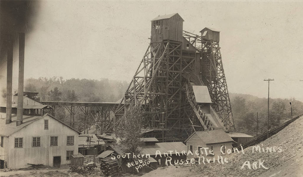
The image at the top is a restoration made with ChatGPT from the original postcard, with instructions to restore it to “museum quality.”


