
Dane County Farmers Market Saturday on the Square, Madison, Wisconsin, June 2, 2018
Photo shared as public domain at Pixabay and Flickr as: Apple Cider Vinegar.
- Only photos specifically identified as such are public domain or creative commons on our pages. All other images are copyright protected or used under the provisions of fair use.

Dane County Farmers Market Saturday on the Square, Madison, Wisconsin, June 2, 2018
Photo shared as public domain at Pixabay and Flickr as “fresh harvested tomatoes.”
- Only photos specifically identified as such are public domain or creative commons on our pages. All other images are copyright protected or used under the provisions of fair use.

Dane County Farmers Market Saturday on the Square, Madison, Wisconsin, June 2, 2018
Photo shared as public domain at Pixabay and Flicker: green onion bunches.
- Only photos specifically identified as such are public domain or creative commons on our pages. All other images are copyright protected or used under the provisions of fair use.

Dane County Farmers Market Saturday on the Square, Madison, Wisconsin, June 2, 2018
Photo shared as public domain at Pixabay and Flickr as Market Fresh Rhubarb.
- Only photos specifically identified as such are public domain or creative commons on our pages. All other images are copyright protected or used under the provisions of fair use.
Post-processing #33 |
")
Yellowstone Lake at Mary Bay, Yellowstone National Park, Wyoming, August 4, 2010 (Composite image of 3 Pentax K10D photos using Autostitch)
Yellowstone Lake Geology1
Lake-bottom surveys (1999 to 2007) of Yellowstone Lake have confirmed that the north half of the lake is inside the Yellowstone Caldera. The survey also mapped “previously unknown features such as large hydrothermal explosion craters, siliceous spires, hundreds of hydrothermal vents and craters and fissures” as well as “young previously unmapped faults, landslide deposits, and submerged older lake shorelines. These features are part of an undulating landscape shaped by rhyolitic lava flows that filled the caldera. The southern half of the lake lies outside the caldera and has been shaped by glacial and other processes. The floor of the Southeast Arm has many glacial features, similar to the glacial terrain seen on land in Jackson Hole, south of the park.”
“These new surveys give an accurate picture of the geologic processes shaping Yellowstone Lake and determine geologic influences affecting the present-day aquatic biosphere. For example, hydrothermal explosions formed craters at Mary Bay and Turbid Lake. Spires may form similarly to black smoker chimneys, which are hydrothermal features associated with oceanic plate boundaries.”
Reference:
- National Park Service
Note:
Post-processing – Image editing to enhance the photo closer to what the eye “saw.” Images in this series are usually selected within a day or so of being edited and are either posted at the time or scheduled for posting at a later date.

Dane County Farmers Market Saturday on the Square, Madison, Wisconsin, June 2, 2018
Photo shared as public domain at Pixabay and Flickr as colorful carrots.
- Only photos specifically identified as such are public domain or creative commons on our pages. All other images are copyright protected or used under the provisions of fair use.
Post-processing #32 |
 photos using autostitch")
Yellowstone River, just above the brink of the Upper Falls of the Yellowstone, Yellowstone National Park, August 4, 2010; panorama from two (Pentax) photos using Autostitch
As the Yellowstone river flows north from Yellowstone Lake, it leaves the Hayden Valley and plunges first over Upper Yellowstone Falls and then a quarter mile (400 m) downstream over Lower Yellowstone Falls, at which point it then enters the Grand Canyon of the Yellowstone, which is up to 1,000 feet (304 m) deep.
Flow can vary from 680 cu ft/s (19 m3/s) in the autumn, to 8,400 cu ft/s (240 m3/s) at peak runoff in late springtime. The 2009/10 snowpack had been significant and combined with a wet spring, the lake level was high with high flow through the river when we visited in August.
Notes:
Post-processing – Image editing to enhance the photo closer to what the eye “saw.” Images in this series are selected within a day or so of being edited and are either posted at the time or scheduled for posting at a later date.
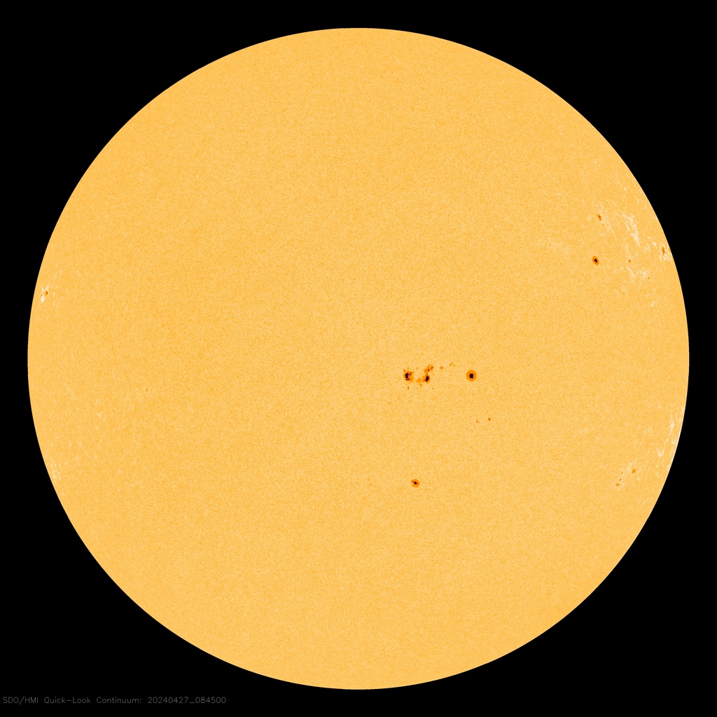
I check the status of solar activity and sunspots semi-regularly – usually a couple times a week, just a quick check, along with several other things I’m interested in.
Sunspots are temporary phenomena on the Sun’s photosphere that appear as spots darker than the surrounding areas. They are regions of reduced surface temperature caused by concentrations of magnetic field flux that inhibit convection. Sunspots usually appear in pairs of opposite magnetic polarity. Their number varies according to the approximately 11-year solar cycle.1
Today, the surface of the sun facing Earth is blank – no sunspots – and it has been for 21 days.
The sun has entered the quiet period of the solar cycle that lasts, on average, 11 years. So far in 2018, there has been 108 days where there were no spots on the surface of the sun. That’s 55% of the year-to-date without sunspots.
From January 1, 2011 through the end of 2015, a period of 5 years, there were only 3 days where the sun didn’t have some spots on the side facing Earth.
The last time there was as many spotless consecutive days was in the summer of 2009 when the sun was emerging from an unusually deep solar minimum.
For some time, scientists have been speculating that declining rates of sunspots may signal a prolonged period of no sunspots and, concurrently, a lowering of global temperatures.
Say Goodbye to Sunspots?
Scientists studying sunspots for the past 2 decades have concluded that the magnetic field that triggers their formation has been steadily declining. If the current trend continues, by 2016 the sun’s face may become spotless and remain that way for decades—a phenomenon that in the 17th century coincided with a prolonged period of cooling on Earth.2
Conjectures about changing conditions on the sun leading to global cooling continue 8 years after the above was written. Many scientists disagree. Unfortunately, the theories cannot be tested in a laboratory and computer modeling may not yet be up to the task.
Perhaps we’ll just have to wait and see.
- Wikipedia
- Say Goodbye to Sunspots? by Phil Beradelli, September 14, 2010, ScienceNOW (accessed July 18, 2010)
Post-processing #31 |
")
Shortcutting trails causes erosion and can be dangerous, Trail to Brink of Lower Falls of the Yellowstone, Yellowstone National Park , Wyoming, August 5, 2010 (Pentax K10D)
Trail switchbacks limit the grade of the trail while gaining elevation on a steep slope. They lengthen the trail and, unfortunately, are sometimes shortcut by impatient hikers – thus damaging or destroying vegetation and increasing erosion problems that can be severe in heavily visited areas, requiring frequent maintenance. In some instances, extensive and expensive revegetation is required and may incorporate blocking elements such as rock walls or logs to discourage shortcutting.
Notes:
Post-processing – Image editing to enhance the photo closer to what the eye “saw.” Images in this series are selected within a day or so of being edited and are either posted at the time or scheduled for posting at a later date.
Post-processing1 #30 |
, August 3, 2010 (Pentax K10D)")
Stormy weather over a pasture (with cows) and the Absaroka Range at Livingson, Montana KOA (across the Yellowstone River), August 3, 2010 (Pentax K10D)
Paradise Valley, Montana2
Paradise Valley is a major river valley of the Yellowstone River in southwestern Montana just north of Yellowstone National Park in Park County, Montana. The valley is flanked by the Absaroka Range on the east and the Gallatin Range on the west.
The Yellowstone River flows through the valley and is noted for world-class fly fishing in the river and nearby spring creeks such as DePuy Spring Creek. The valley hosts other natural wonders such as several natural hot springs, including Chico Hot Springs near Emigrant, Montana, La Duke Hot Springs near Gardiner, and Hunter’s Hot Springs near Livingston.
Mount Cowen is the largest peak near the valley, at 11,212 feet (3,417 m) in elevation. It is located in the southern portion of the valley on the eastern side of the river within the Absaroka mountain range.
- Post-processing – Image editing to enhance the photo closer to what the eye “saw.” Images in this series are selected within a day or so of being edited and are either posted at the time or scheduled for posting at a later date.
- Paradise Valley (Montana) – Wikipedia


