Marais des Cygnes.

 image

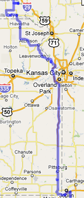
After driving in traffic on Friday,  we really wanted to take a route that would not be as heavily traveled as US 71 in western Missouri.  We’ve traveled that route quite a few times in the past and it can be quite busy, with quite a bit of commercial traffic.  From Joplin, we headed west on I 44.  Just before we got to Oklahoma, the gps routed us into the southeast corner of Kansas and before long we were heading up the eastern edge of Kansas on US 69.

Much of the route we took was on roads that approximates the old military trail used by the Army to transport troops and supplies between the frontier forts. In 1836, President Andrew Jackson authorized $100,00 to build a military road from Fort Snelling in Minnesota to Fort Gibson in what is today Oklahoma.  It was to be used for frontier defense and a patrol system, and, later for commerce.

2010 07 03 017ed

About 30 miles north of Fort Scott, we came across another nice little rest stop.  It’s just off US 69 about a quarter mile or so east on Highway 52, adjacent to the Marais des Cygnes National Wildlife Refuge.

We ate lunch there and took a short walk.

There is an interesting little interpretive trail through an area with prairie grasses and wildflowers. Signs along the trail briefly describe some of the history of the area, from the times before the explorers and pioneers through the travelers of today.

In the 1850s, before the Civil War, the area we were driving through saw a lot of armed conflict.  Pro and anti-slavery factions from the east had come to Kansas for the fight over whether Kansas would become a free state or a slave state.  On May 19, 1858, pro-slavery forces came from Missouri and captured 11 free-state men, killing five of them in a ravine just to the northeast of the rest stop in what came to be known as the Marais des Cygnes Massacre.

2010 07 03 004ed

(Click on images to view larger version)

2010 07 03 015ed

(Each travel journal post is published on Exit78 and Haw Creek Out ‘n About.)

1 comment
None

Downed

Downed Timber in Notch trail went through, Seven Hollows Trail, Petit Jean State Park, Arkansas

Downed Timber in a notch that the  trail went through.  The trees had been killed by a forest fire and later fell.  It made getting through the notch a tad difficult.

Seven Hollows Trail, Petit Jean State Park, Arkansas


Gallery – Petit Jean State Park and Petit Jean Mountain

(click on image for larger version)


Petit Jean State Park and Petit Jean Mountain information:

Seven Hollows Trail (loop trail: 4.5 miles, 4 hours; to Natural Bridge: 1.3 miles; to Grotto: 2.25 miles) actually only goes through the four most interesting hollows. Rated as moderate to hard, this trail passes through open areas, immense rock formations, rock fields with near dessert-like conditions and the lush moss and fern understory of a hardwood forest. The trail passes through areas that are successfully recovering from an August 2000 wildfire. The trailhead begins 1 mile west of Mather Lodge on highway 154.


See more of our Image Galleries at Haw Creek.


0 comments
None

Unknown

Unknown no longer.  An email from a reader said, “The bark, bloom, and leaves indicate this to be a type of locust tree. The Black Locust makes excellent fence posts for longevity but are more labor intensive to prepare and install than the readily available treated pine poles that are now being used. The White Locust is a runner up.”

I did a search on images with the new information and learned that it is a black locust tree.  Thanks, again, Howard.

Great Smoky Mountains National Park, May 5, 2009

This tree and its interesting blossoms were on the bank of the Little River in Great Smoky Mountain National Park.

I don’t know what kind of three it is, though I’ve searched online on location and description.

May 5, 2009, Tennessee


Gallery – Great Smoky Mountains National Park

(click on image for larger version)


Wikipedia: Great Smoky Mountains

Cove hardwood forests, which are native to Southern Appalachia, are among the most diverse forest types in North America. The cove hardwood forests of the Smokies are mostly second-growth, although some 72,000-acre (290 km2) are still old-growth. The Albright Grove along the Maddron Bald Trail (between Gatlinburg and Cosby) is an accessible old-growth forest with some of the oldest and tallest trees in the entire range.[15]

Over 130 species of trees are found among the canopies of the cove hardwood forests in the Smokies. The dominant species include yellow birch, basswood, buckeye, tuliptree (commonly called “tulip poplar”), silverbell, sugar maple, magnolia, hickory, and hemlock. The American chestnut, which was arguably the most beloved tree of the range’s pre-park inhabitants, was killed off by a blight in the 1920s.

The understories of the cove hardwood forest contain dozens of species of shrubs and vines. Dominant species in the Smokies include the redbud, dogwood, rhododendron, mountain laurel, and hydrangea.


See more of our Image Galleries at Haw Creek.


0 comments
None

On the road again √

road_trip_2010

Travel Journal

Tonight, we’re camped near Joplin, Missouri, heading north and west, aiming generally in the direction of Wyoming.

My intents are to post frequently and share images on a regular basis.  No promises, of course, but those are my intents.

Besides the destination spots, I’ll also try to share some of what we see “along the way.” (see note at bottom)

Today was a planned short travel day.  We finished getting everything loaded and made it out of the driveway before our intended 10 AM departure time.  After traveling west on Interstate 40, we turned north on I540.

Brentwood Community Rest Area, Arkansas

Interstate 540 is a relatively new road.  For the first 15 years we lived in Arkansas, our trips to northwest Arkansas to visit Karen’s family was over US 71, which the new interstate parallels.  Both roads go over some of the roughest and scenic parts of the Boston Mountains.  US 71 used to have very heavy traffic – along with a number of fatalities each year.

I540 was fully opened between Ft. Smith and Bentonville in the late 90s.

Today, around noon, we were trying to decide where to pull over to take a break and  fix our lunch.  Just before we got to the Winslow exit, I remembered a rest area on highway 71 that we used to stop at almost every time we went over the mountains.  We weren’t sure that it would be still open since almost all of the through traffic bypasses that area now.  We decided to check it out.

We were pleased to find that the rest area is not only still open, but has been significantly improved.  The rest room building and the area around it is still much the same, but remodeled, with new fixtures, and cleaner overall.

Located on US 71, between Winslow and West Fork, the park now boasts a 1/3 mile fitness trail and other recent improvements.  Part of the trail is on the bank of the West Fork of the White River, which at this time of year is normally little more than a trickle.

No longer a State of Arkansas facility, it is now the Brentwood Community Rest Area.  With traffic moving to I540 after that freeway opened in the late 90s, rest area usage plunged.  The Arkansas State Highway Department closed it in 2001 because of vandalism and lack of use.  It was subsequently reopened with the idea of locating a law enforcement substation there.  After that never materialized, the park was on the verge of being closed again when local residents volunteered to take care of daily maintenance.

West Fork of the White River.

Note:

One of the things I want to do is include video snippets – short little pieces that don’t include voice, but do include sounds and images from what we are seeing.  Our little smart phones are video capable – no zoom, so they are kind of limited.

While most photos that I include will be from my Pentax SLR, I will also be using some from my phone – which is the source of both photos in this post.

Tomorrow, we cross into Kansas and head north to Nebraska.

(Each travel journal posts is published on Exit78 and Haw Creek Out ‘n About.)

0 comments
None

Old Grill

Museum of Automobiles, Petit Jean mountain, Arkansas, July 2005

On an old Ford

at the Museum of Automobiles
on Petit Jean Mountain,
adjacent to Petit Jean Mountain State Park, Arkansas


Gallery – Petit Jean State Park and Petit Jean Mountain

(click on image for larger version)


Petit Jean State Park and Petit Jean Mountain information:

The Museum of Automobiles, located east of the main part of the Petit Jean State park on Petit Jean Mountain, includes a permanent collection of 30 automobiles donated by supporters from Arkansas and surrounding states.  The museum was founded in 1964 by the late Governor Winthrop Rockefeller, housing his collection of antique and classic automobiles until the collection was sold in 1975, with building and grounds donated to the Arkansas Department of Parks.  In 1976, a non-profit corporation was formed and reopened the museum with cars loaned from collectors around the country.  The national headquarters of the Mid-America Old Time Automobile Association is located in the museum.  The museum co-hosts with MOTAA in June the annual Petit Jean Antique Car Show and Swap Meet.  The museum also hosts a Fall Swap Meet and Military Vehicle Show.  Hours are 10 am to 5 pm daily.


See more of our Image Galleries at Haw Creek.


0 comments
None

Hoops

Great Smoky Mountains National Park, May 6, 2009

I suspect these are probably hoops for wooden barrels.

Mountain Farm Museum

adjacent to the Oconaluftee Visitor Center and near Cherokee, North Carolina.

Great Smoky Mountains National Park, North Carolina and Tennessee


Gallery – Great Smoky Mountains National Park

(click on image for larger version)


Museum  information from the National Park Service website:

The Mountain Farm Museum is a unique collection of farm buildings assembled from locations throughout the park. Visitors can explore a log farmhouse, barn, apple house, springhouse, and a working blacksmith shop to get a sense of how families may have lived 100 years ago. Most of the structures were built in the late 19th century and were moved here in the 1950s. The Davis House offers a rare chance to view a log house built from chestnut wood before the chestnut blight decimated the American Chestnut in our forests during the 1930s and early 1940s.


See more of our Image Galleries at Haw Creek.


0 comments
None

Approaching the top

Fall River road in Rocky Mountain National Park, Colorado

Going above timberline on Fall River Road , headed toward the Alpine Visitor Center and gift shop on Trail Ridge Road in Rocky Mountain National Park, Colorado.


Gallery – Fall River and Trail Ridge – September 2, 2009

(click on image for larger version)


Fall River Road was the first road to cross the Continental Divide in Rocky Mountain National park.  It provided a connection from Estes Park over Fall River Pass to Grand Lake.  The road was constructed between 1913 and 1920 by the State of Colorado and the two counties, Larimer and Grand, through which it crossed.  It was the principle road across the park until completion of Trail Ridge Road in the 1930s, which follows the old route on the western side. 

The nine-mile eastern segment, between Endovalley and Fall River Pass, remained in use until it was closed by rock slides in the 1950s.  It was reopened in 1968 as a one-way motor road, widened over the years, but never paved. The restored segment offers motorists an experience similar to those of the first over-the road travelers in the park.


See more of our Image Galleries at Haw Creek.


0 comments
None

Architectural details

Lake Yellowstone Hotel, Yellowstone National Park - September 15, 2007 

Lake Yellowstone Hotel, Yellowstone National Park, Wyoming


Gallery: Around the Lower Loop, September 15, 2007 

(click on image for larger version)


The Ionic columns, dormer windows, and deep porticos on this classic yellow building faithfully recall the year it was built: 1891.  (Frommer’s Montana & Wyoming by Eric Peterson)


See more of our Image Galleries at Haw Creek.


0 comments
None

Tossing grass

2009 08 31 039ed

This guy was swishing his horns back and forth in the long grass, apparently gathering up enough that he could toss some of it in the air over his back.  Apparently, this is part of an elk’s instinctive rutting behavior.


Gallery: Moraine Park Elk and Estes Park area – September 4, 2009  (click on image for larger version)


See more of our Image Galleries at Haw Creek.


0 comments
None

Legal images for your blog?

I like to incorporate images into my blog posts.  Because I’m an amateur photographer, often that photo is the object of the post.

image

If my post is going to be commentary on something or other, though, I like to use a photo that has something to do with the topic.  For instance, in the post Leave all that rush – rush – rush at home! – don’t bring it here, “here” was Yellowstone National Park.  For that post, a picture of the iconic Old Faithful Geyser was a good choice.

Since I use my own images most of the time, copyright is not usually a concern.

Sometimes, though, I can’t think of any photos that would fit what I’m going to be writing about.  That’s when it’s time to start searching for something that will go with the topic – something that is also legal.  I’m not always successful in finding the right image, but sometimes it works.

imageI like to use flickr.

The first thing I’ll do is search on something related to the topic I’m writing about.  The flickr search box is on the upper right hand side of the page.

I’ll search “confederacy,” since I’m doing a civil war blog, and see what I get.

imageI’m generally conscientious when it comes the authors’ rights, so I want to make sure whatever image I pick can be used without restrictions.  To accomplish that in flickr requires a second level of search.  On the upper right side of the page, Ill select “Advanced Search,” which will take me to a page with a number of additional search options.

image I’m looking for content that I can use with no restriction.  Scrolling to near the bottom of the page, I find the Creative Commons options.  I’ll check all three boxes and then click the search button below.

After that, all the images that show up should be available under Creative Commons.  But how can we be sure?  It’s not obvious at first.

image Once an image has been selected, there is a row above the image on the photo page.  I select “all sizes.”  Once we get to that page, there is a statement at the top that says “All sizes of this photo are available for download under a Creative Commons license.”  The link takes you to a couple of icons below the picture.  The icons are linked to pages that describe the limitations and requirements of usage.

What do you use for finding images to use on your blog?

0 comments
None