Wind Blown

Travel Journal 7/13/2010

We left our nice, lake side camping spot a day early.  We are now sitting at the KOA in Dubois, Wyoming.

It was the wind. 

It was just too much.

We had planned a nice relaxing day – with a little sight seeing before lunch and relaxing by “our” little beach, but the wind was just to much for “relaxation.

The wind had been strong when we got back to the camper yesterday.  Karen had cooked our supper on the leeward side of the the motor home, which is also where we sat most of the evening, out of the direct wind.

The video was shot where we were sitting out of the wind, yesterday.  It was worse today.  The weather forecast was calling for 15 to 30 mile per hour winds, with gusts reaching as high as 50 mph. 

Driving the motor home in the wind was not pleasant.  Fuel economy suffered, even though I was driving 10 mph below the speed limit, as we were going directly into the wind.

Tomorrow we are headed into Grand Teton National Park.  We don’t have a reservation for a camp site, so we will see if we can get into a campground in the park.  If not there are other campgrounds in the forest outside the park.

I’m not sure when I will be posting next.  Internet service is unlikely where we will be going, but Jackson, Wyoming is a popular place, with lots of upscale development over the years.  Surely we will be able to find Starbucks.

(Each travel journal post is published on Exit78 and Haw Creek Out ‘n About .)

1 comment
None

Bypass Flow


Travel Journal

This huge spray of water is bypass flow around the hydroelectric plant at Kingsley Dam, near Ogallala , Nebraska.  It was originally installed to bypass the hydro plant when the plant was idle or when more flow was needed downstream for irrigation or minimum stream flow requirements.  Today, the bypass valve is used regularly during the summer to maintain oxygen for the trout population in the downstream Lake Ogallala.

We visited this spot on July 8, 2010.

(Each travel journal post is published on Exit78 and Haw Creek Out ‘n About .)

0 comments
None

Pathfinder

We moved on down the road yesterday and found a pretty spot right on the shore of Pathfinder Reservoir west of Casper, Wyoming.  It was a short drive, only about 90 miles, from our last campground.

Pathfinder Reservoir Pathfinder Reservoir

We had been planning on stopping here 2 days, maybe 1 if we didn’t care for it much.  However, after getting here, we decided to pay for three nights.

As I type right now, we can hear the waves lapping on the shore just a few feet from our camper’s door and the leaves rustling in the breeze. 

When we got here yesterday afternoon, Sunday, there were quite a few campers here and at another campground a little ways up the road.  Not long after we had set up camp, nearly everyone was gone, except for a few people swimming.  By the time we at supper, everyone was gone, though a little later, a young couple tent camping camp in and set up their camp on the opposite side of the campground.

We don’t have internet or phone service here.  That may be the case in many of the places we will be visiting.  I am using Windows Live Writer for this post and when we get someplace with internet service, I’ll publish it.

Today, we plan to visit Independence Rock and some other Oregon/Mormon/California Trail landmarks.  We’ll be taking the laptops along so that, if we get to a McDonalds or a Starbucks or some other place with internet service, we can upload our blog posts.

1 comment
None

A Soddie

the_soddie

The man and woman on the right are my great-great-grandparents, James Wesley Goad and Olive Orabelle Wineland Goad, in front of their house in 1899, with his brothers, sisters, and their spouses.

Jim and Ollie Goad built a sod house about 1890 on their land three miles west, six miles north of Waldo, in Liberty Township. After it was completed, a steady stream of wagons was seen going to and from their home. On investigation, the sheriff found neighbors carrying Goad water home by the barrel. Many wells in early days produced only surface water, unpalatable and unsanitary. Jim and Ollie were happy to share with others less fortunate.

On Thursday, we came across a similar sod house at Ash Hollow State Park, Nebraska:

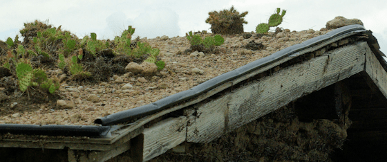
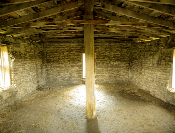
sod house at ash hollow state park, nebraskaThis soddie was built on 2 days in 1967 as part of the Ash Hollow Centennial Pageant, when a nearby sod house  was reconstructed.  On the prairies, other materials for construction were a good distance away.  At Ash Hollow, the original homestead dwelling at this location had been built of stone.

Yes, there is stuff growing on the roof.

image
The inside was – well, it was a shelter from the elements.

image

How would you like living in something like this?

0 comments
None

Two very different places

Travel Journal

We visited a couple of very different places today.  The first, Fort Fetterman State Historic Site, is situated on a windy plateau above the valleys of LaPrele Creek and the north Platte River.  The second, Ayrs Natural Bridge, is in a mountain canyon.

Yet, they are only a relatively few miles apart.

I will post more on both of these at a later point, with photographs that show more of each place.

We plan to move on down the road aways tomorrow.  I don’t know if we will have internet service.

(Each travel journal post is published on Exit78 and Haw Creek Out ‘n About .)

0 comments
None

Indian Cave Petroglyphs

Indian Cave State Park, Nebraska, petroglyph-a Indian Cave State Park, Nebraska, petroglyph-b Indian Cave State Park, Nebraska, petroglyph-c

Commenters on the post on Indian Cave State Park asked for more photos of the petroglyphs there.  There are about 15 in the cave.  These, and the one on the earlier post, are the only ones I found.  (click on any of the images to view a larger version)

Other petroglyph images that we’ve seen:

Note: These are in online photo galleries.

Arches National Park, Utah

Petit Jean State Park, Arkansas

Posted from Douglas, Wyoming.

0 comments
None

Water Fun

Canton Lake, Oklahoma, August 29, 2009-2

Canton Lake, Oklahoma


Gallery – Canton Lake – August 29, 2009

(click on image for larger version)


Core of Engineers:

Canton Lake is located in west Oklahoma on the North Canadian River, 2 miles north of the town of Canton. This man-made lake offers extensive opportunity for outdoor recreational activities. Canton Lake plays host to a large number of campers, picnickers, boaters, fishermen, and hunters every year. It is one of the few places that offers these types of recreational opportunities in western Oklahoma. Its gently sloping sandy beach is an open invitation for swimming and sunbathing. Water skiing is popular on the broad expanse of water paralleling the dam where winds are subdued.

The Corps of Engineers operates five multi-use recreation areas which offer a combination of overnight camping and day-use opportunities to the visiting public. Sightseers may view the lake from the 2.5 mile stretch of State Highway 58A which crosses over Canton Dam. Three parking areas/pullouts with fishing jetties are located on the dam. Other features include a nature trail, overlook visitor center, outdoor amphitheater, scenic drive, and active prairie dog town.

Canton Lake is NW Oklahoma’s leading fisherman’s paradise. It provides several species of fish, including crappie, white bass, hybrid bass, channel catfish, and largemouth bass. Canton is most widely known for an abundance of walleye and has become the primary source of walleye eggs used to stock other Oklahoma lakes. Canton Lake hosts an annual Walleye Rodeo fishing derby during the month of May.


See more of our Image Galleries at Haw Creek.


0 comments
None

A Long Day

Sunset near Douglas, Wyoming

Travel Journal

We made it to Douglas, Wyoming, this evening, after stopping at quite a few historical markers and four different landmarks along the western migration trails.  It was a longer travel day than most, even though we only traveled a total of about 250 miles, counting side trips.

I’ll be publishing individual posts on the different places we’ve stopped and try to include some information about each rather than try to include everything we saw in a day into one post.

The picture above is a composite image from several photos that were taken from the highway near the campground. (Click on image to view larger version)

(Each travel journal post is published on Exit78 and Haw Creek Out ‘n About .)

3 comments
None

Across Nebraska

From Indian Cave State Park, we headed west across Nebraska, much of our journey paralleling The Great Platte River Road.

nebraska-2009

Much of the westward travel in the 1800s followed this route – mountain men hunters and trappers, western explorers, pioneers, gold and silver miners – all following the river, on one side or the other, through a seemingly barren land.  The people that went across knew it by other names – Oregon Trail, California Trail, Mormon Trail, Pony Express, the first transcontinental railroad, and Lincoln Highway.  For the first 15 years of my life, it was home.  I grew up in North Platte, which is situated between the North and South Platte Rivers, just upstream of where they join to form the Platte.

We are currently at Lake Ogallala, getting ready to head further west along the Oregon Trail, stopping at many of the historic spots along the way.  During the week, we had a good visit with my dad, step-mom and sister. My dad’s house has been for sale for quite some time, but, the morning of the day we got there, it sold.  They all be moving out to the coast of Oregon early next month.  I guess we’ll have to plan a future trip out there.

We’ll be seeing a lot of places during the next month.  I’ll be posting about a lot of them, as I can, and, in some instances, I may be posting more than one post in a day, with each post focusing on a particular place or feature.

We’ve only had two days, so far, where we didn’t have internet access.  It would be nice if we would continue to be able to get online, but it is likely that we won’t be able to in some of the places we are headed.

(Each travel journal post is published on Exit78 and Haw Creek Out ‘n About .)

0 comments
None

Indian Cave State Park, Nebraska

leg_two_2010

Travel Journal

The second leg of the trip was a little over 300 miles. After leaving the rest area near the Marais des Cygnes National Wildlife Refuge, we continued north with the intent of bypassing Kansas City.  For the most part we did, though we did detour into some suburb in a vain attempt to find a service station that had diesel fuel.  We saw lots of shopping centers and big box stores, but only 3 fueling stations and none of them carried diesel. 

Fortunately, when the motorhome fuel meter hits 0 and the “fuel now” light comes on, there is still 5 gallons of fuel left.  It was actually intentionally designed that way.  We never let it go for very long after that and try not to let the tank get below 1/4th by indicator.

Our route did get away from the freeway and we did have to go through some towns, including Leavenworth, Kansas – we passed right by Fort Leavenworth and the Federal/military penitentiary there.

Our stopping for the next couple of nights was Indian Cave State Park.


The cave at Indian Cave State Park

Stairs to cave

Petroglyph in the cave at Indian Cave State Park

Petroglyph

Cave at Indian Cave State Park

Panorama from several photos of cave area

Mud deposited by flood on road at Indian Cave State Park, Nebraska

Mud deposited by flood on road.

One room school at St. Deroin, Indian Cave State Park, Nebraska

One room school at St. Deroin town site.

Indian Cave State Park, Nebraska, flooding of the Missouri

Flooded road at Indian Cave State Park

(click on any photo to view larger image.)

Indian Cave State Park is named for a cave that overlooks the present channel of the Missouri River.  Petroglyphs in the cave are evidence that the cave was used by prehistoric native peoples.   There is no evidence of any permanent structures.  The cave – actually a limestone overhang – was probably used primarily as a temporary shelter for nomadic hunters.

There are 15 or more petroglyphs scattered among the more recent modern graffiti in the cave.  They were created by nomadic tribesmen 1500 to 1800 years ago.  Many of them are of American bison (buffalo).

Stairs and decking with railings help to limit modern wear and tear on the cave. 

While visitors are not supposed to go beyond these barriers, it didn’t surprise us to see a father setting a fine example for his kids by climbing over a railing and climbing up the side of a hill past a sign stating that climbing up the hill is prohibited.  (I’m not going to rant on that pet peeve.)

If we had gotten to the park a few days earlier, we would not have been able to visit the cave.  When Louis and Clark went up the Missouri in the early 1800s, the channel was a mile and half from the cave.  Today, however, the river is just below the cave, with a road running along the bank.  The river had been over the road the week before, but river level had been dropping for several days.  The mud left by the flood was several inches deep over the road, but had been “plowed” to the sides before we got there.

The river was still above flood stage, though.

We had planned to spend most of the 4th of July in the park, including doing some hiking.  Unfortunately, it looked like the weather forecast was going to right on target for a change and it was going to rain.

Before the rain started, we were able to get in a short walk and visit the site where a small river side settlement had once existed.

Shortly after that, the rain started.  It was heavy over a wide area.  Holiday festivities were canceled or limited over a wide area – we went to Lincoln to see a movie.

The rain was enough that the flooded Missouri – which had been dropping – started rising to a new flood crest.

(Each travel journal post is published on Exit78 and Haw Creek Out ‘n About .)

1 comment
None