Independence Rock

One of the reasons we camped at Pathfinder Reservoir last month was its proximity to Independence Rock.

Independence Rock, Wyoming

Independence Rock is another landmark along the westward emigrant trails (Oregon Trail, California Trail, Mormon Trail.)

In 1841, Jesuit missionary Pierre Jean De Smet wrote, “The first rock we saw, and which truly deserves the name, was the famous Independence Rock.  It is of the same nature as the Rocky Mountains.  At first I was led to believe that it had received this pompous name from its isolated situation and the solidity of its base, but I was afterward told that it was called so because the first travelers who thought of giving it a name arrived at it on the very day when the people of the united States celebrate the anniversary of their emancipation from Great Britain… lest it might be said that we passed by this lofty monument of the desert with indifference, we cut our names on the south side of the rock under initials (I. H. S.) which we would wish to see engraved everywhere, and along with a great number of others, some of which perhaps ought not to be found anywhere.  On account of all these names, and of the dates that accompany them, as well as the hieroglyphics of Indian warriors, I called this rock on my first journey ‘The Great Record of the Desert.’”

When we climbed to the northern highest point on the rock, we didn’t know that the trails had actually passed on the south side – today’s modern highway and rest area  is to the north – so we didn’t really search for names on the south, though we did take the trail all the way around.

Independence Rock, Wyoming

We did find some old name carvings on the top and, unfortunately, some more modern engravings and markings, though it is now illegal as this is a national historic site.

Independence Rock, Wyoming Independence Rock, Wyoming
0 comments
None

Grand Prismatic Spring – from above!

As promised to a couple of visitors to this blog, here is a view of Grand Prismatic Spring in Yellowstone National Park, Wyoming, from a small hill to the west.  (Click on images for larger versions)

Grand Prismatic Spring, Yellowstone national park, Wyoming

The following panorama is a composite of three photographs:

Grand Prismatic Spring, Yellowstone national park, Wyoming

From Wikipedia:

The Grand Prismatic Spring in Yellowstone National Park is the largest hot spring in the United States, and the third largest in the world, next to those in New Zealand. It is located in the Midway Geyser Basin.

History

The first records of the spring are from early European explorers and surveyors. In 1839, a group of fur trappers from the American Fur Company crossed the Midway Geyser Basin and made note of a "boiling lake", most likely the Grand Prismatic Spring, with a diameter of 300 feet (90 m). In 1870 the Washburn-Langford-Doane Expedition visited the spring, noting a 50-foot (15 m) geyser nearby (later named Excelsior).

Color

The vivid colors in the spring are the result of pigmented bacteria in the microbial mats that grow around the edges of the mineral-rich water. The bacteria produce colors ranging from green to red; the amount of color in the microbial mats depends on the ratio of chlorophyll to carotenoids and on the temperature of the water that favors one bacterium over another. In the summer, the mats tend to be orange and red, whereas in the winter the mats are usually dark green.[5] The center of the pool is sterile due to extreme heat.

The deep blue color of the water in the center of the pool results from the intrinsic blue color of water, itself the result of water’s selective absorption of red wavelengths of visible light. Though this effect is responsible for making all large bodies of water blue, it is particularly intense in Grand Prismatic Spring because of the high purity and depth of the water in the middle of the spring.

0 comments
None

Faster than you’d think….

These two photos were taken just a few seconds apart.  In the first, this bull bison (buffalo) is plodding along near the road.  Then, all of a sudden, he whips around and starts chasing another buffalo.  The second photo is just as he is turning.

These critters can be fast and dangerous.

2010 08 05 013 2010 08 05 014ed

Posted from Old Faithful Inn, Yellowstone National Park, Wyoming.

0 comments
None

Across South Dakota

image

We left Custer State Park this morning, after camping 2 nights there.

We had a great campsite, a shady spot right on the banks of a stream – the only thing we could hear after we went to bed.  (Tonight, we in a commercial campground right next to I90 – 11 pm on a Saturday night and there is still some traffic noise.)

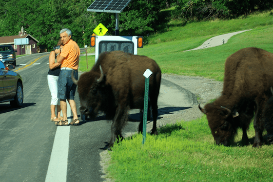
Today was the first day since the 3rd that we didn’t see any buffalo (American bison).  And, of course, in Custer State Park, we saw plenty of people gaga over the buffalo.

image image

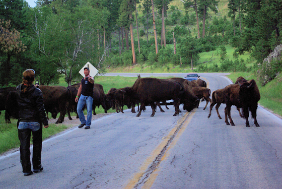
The guy in the second photo was trying to get closer and closer to the buffalo – very slowly, very carefully and very stupidly.

We were in our car, stopped and I wasn’t planning on moving until this guy got away from the buffalo.  A fellow in a white car behind us came up and asked if we could move over so they could drive through.  I told him, “No” and that I wasn’t moving because I didn’t want to spook the animals and make it more dangerous for the people that were way too close to the buffalo.

Well, the impatient guy actually asked the fellow out there to move, telling him that I wasn’t going to drive through with him there.

Fine.  The guy moved and I drove through the herd of buffalo.

That’s right.  I drove forward slowly, just like I would if I were trying to drive through a herd of cattle or sheep.  And just like cattle or sheep, these big critters just moved out of the way – and the guy in the white car who was so impatient stopped in the middle of the herd so he or his family could get some pictures.

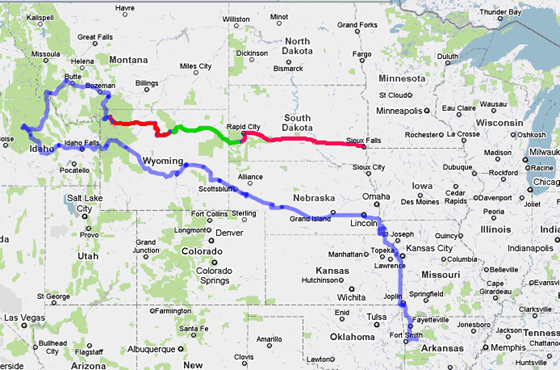
The dark red on our route is from Fishing Bridge RV Park in Yellowstone to Sitting Bull Campground in the Bighorn National Forest, west of Gillette, Wyoming.  The next segment is from Sitting Bull Campground to Game Lodge Campground in Custer State Park, South Dakota.  The last segment is today’s journey to Sioux Falls, SD.

I’m certainly glad that we only witnessed fools around critters this trip and am most definitely glad we didn’t see any tragic results, though the possibilities were there.

1 comment
None

Fort Caspar

July 11, 2010 – After visiting the (interpretive center – include link), we drove to another part of Casper, Wyoming, to visit Fort Caspar Park, where there is a museum and a “reconstructed” Fort Caspar.  The fort reconstruction was built in 1936 by the Works Progress Administration and is based on the diagram of the post made by Lieutenant Caspar Collins.

Fort Caspar, Casper, Wyoming

Telegraph office:

Fort Caspar Telegraph office, Casper, Wyoming Telegraph station, Fort Caspar, Wyoming

Post suttler’s store:

Fort Caspar Sutler Store, Casper, Wyoming 

Casper, Wyoming stops

Fort Caspar is located at the red pin on our route map.

Protecting employees and property of the Overland Mail Company and maintaining the Pacific telegraph line brought the United States Army to central Wyoming in 1862.  Lieutenant Colonel William O. Collins, regimental commander of Companies A, B, C, and D of the 1st Battalion of the 6th Ohio Volunteer Cavalry reached Fort Laramie on May 30, 1862, and received orders on June 3 to proceed with 3 companies to South Pass, following the westward emigrant trails.

During the first week of June, troops from the remaining company began establishing an outpost at Guinard’s bridge over the North Platte River.  Soldiers spent much of the summer repairing the telegraph line damaged by raiding Shoshone, Lakota, Cheyenne, and Arapaho.

Over the next several years, the post at the North Plate bridge continued to grow. In October, 1865, there  was 242 enlisted soldiers and 14 officers at what was then called Platte Bridge Station.

Early on the morning of July 26, 1865, Lieutenant Caspar Collins of the 11th Ohio Volunteer Cavalry led a troop of men from the 11th Kansas Volunteer Cavalry to reinforce army supply wagons coming into Platte Bridge Station.  Only a mile west of the post, they were ambushed by members of the Lakota, Cheyenne, and Arapahoe nations.  Four troopers and Lieutenant Collins were killed in the retreat to the post.

By special order, Major General John Pope changed the name to Fort Casper to honor Lieutenant Caspar Collins.  Pope chose the  lieutenant’s  first name because there was already a Fort Collins, named for Caspar’s father.  The young officer’s name was misspelled as Casper in the orders.

Fort Casper was very short-lived due to changing conditions on the frontier.  When orders were issued to abandon Fort Casper on October 19, 1867, troops and “all useful materials,” including buildings were transferred to Fort Fetterman.

0 comments
None

My travel souvenirs

We don’t buy souvenirs often. 

As much as we travel, we don’t have enough room for any travel collectables.

However, I do have souvenirs of the places we’ve been – my photos.

And, boy, do I have a lot of them.

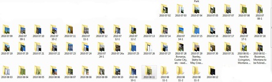
The picture below shows just the photo folders on my computer for this trip.  I’ve completed going through the photos in the folders that have the long names.  They are ready for the next step, which is to create an online photo gallery with the processed images.

temp

We do have internet access here in Custer State Park, so will be catching up on stuff and possibly prepping some posts.

0 comments
None

Yellow-bellied!!!

Marmot, that is:

2010 08 11 e 024ed

We saw this fellow as we were leaving Yellowstone National Park on Wednesday.

From Wikipedia:

The yellow-bellied marmot (Marmota flaviventris), also known as the rock chuck, is a ground squirrel in the marmot genus.

Yellow-bellied marmots usually weigh between 5 and 11 pounds (2 and 5 kg) when fully grown. They get fatter in the fall just before hibernating.

The yellow-bellied marmot lives in the western United States and southwestern Canada, including the Rocky Mountains and the Sierra Nevada. It inhabits steppes, meadows, talus fields and other open habitats, sometimes on the edge of deciduous or coniferous forests, and typically above 6,500 feet (2,000 m) of elevation.

Their territory is about 4 to 7 acres (2 to 3 ha) around a number of summer burrows. Marmots choose to dig burrows under rocks because predators are less likely to see their burrow. Predators include wolves, foxes, and coyotes. When a marmot sees a predator, it whistles to warn all other marmots in the area (giving it the nickname "whistle pig"). Then it typically hides in a nearby rock pile.

0 comments
None

Traveling east for a while….

image

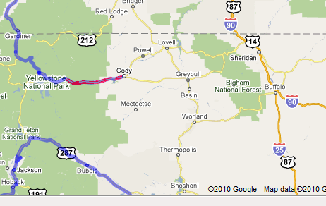
We left Fishing Bridge RV Campground in Yellowstone National Park this morning at about 8 a.m.  Right now, we are at the Cody, Wyoming, Walmart for stocking up on supplies, lunch, and a “quick” internet stop.

Tonight, we’ll be camping somewhere in the mountains west of Sheridan, Wyoming.  Tomorrow, we’ll be heading for Custer State Park in South Dakota, where we have campground reservations for two nights.  From there we’ll be heading to near Madison, Wisconsin, which we’ll spread over three days travel.  We may not be able to be back online until sometime on Saturday.

The red line on the map is today’s travel to this point.

Have a great rest of the week, all!  😉

0 comments
None

Grand Prismatic Spring

Grand Prismatic Spring

Click on picture for larger image.

0 comments
None

Crowds at Old Faithful

Normally, when you see images of Old Faithful, you don’t see how many people are there for the nearly hourly eruption. 

I thought I’d provide a little different view.

2010 08 06 023panoed 2010 08 06 025ed 2010 08 06 021

No matter how many times we visit Yellowstone, Old Faithful is worth seeing.

1 comment
None