Bull Trout–Part Deux

Bull Trout Campground

On July 26, we moved from Arco, Idaho to Bull Trout Campground, about 26 miles down the road west of Stanley.  The campground is next to two lakes, Bull Trout Lake and Martin Lake.  Our campsite was in the newer section of the campground and  was just a short walk from the smaller of the two lakes.

We didn’t get over to the larger lake – Bull Trout – other than driving the loops to see what the other campsites looked like.  We walked the short distance to Martin Lake and hiked all the way around it.

The campground was 1.9 miles down a very dry dirt road whose surface was like powder.  Fortunately, it rained that night.  The rain washed the worst of the dust off the car and there was very little road dust for the rest of our stay.

Martin Lake next to Bull Creek Campground trail by Martin Lake next to Bull Creek Campground Martin Lake next to Bull Creek Campground

The campground elevation is 6900 ft in a mixed growth forest of Douglas fir and lodgepole pine. Wildflowers are plentiful.

Martin Lake next to Bull Creek Campground

July 29, 2010 posts:

0 comments
None

From clear skies to blowing and blustery.

July 25, 2010, Arco, Idaho

2010 07 25 007panoed2

After a day trip with crystal clear skies for most of the day, it turned cloudy and very blustery as we were getting back to the campground. transparent2

2010 07 25 130panoed 2010 07 25 153panoed
0 comments
None

I’m part of a facebook “fan” page

Yesterday, I was invited to join two other bloggers on The American Civil War page on facebook.  We’re  following the history of the war as it unfolds day by day.

1,385 people like The American Civil War page.  Winking smile

image
0 comments
None

Mt. Borah lifted by a quake

photos – July 25, 2010

Mount Rorah and the Lost River Range image

Located in the central section of the Lost River Range, Borah Peak (aka Mt. Borah) is the highest mountain in Idaho.

On Friday, October 28, 1983, a magnitude 6.9 earthquake centered near the base of the mountain lifted Borah Peak about a foot, while the Lost River Valley floor dropped up to 7.5 feet in places.  It also resulted in a 20-mile scarp along the base of the Lost River Range and sand boils near Chilly Butte and the Lost River and Pahsimeroi valleys.  Two elementary school students were killed in Challis.

Mount Rorah and the Lost River Range Mout Borah earthquake scarp

The scarp – highlighted in blue – resulting from the quake can still be seen 27 years later. The red line highlights a dirt “road.”  The above image was cropped from the photo below.

Mout Borah earthquake scarp
0 comments
None

Blog of the Week

Karen’s blog, Quilt’s…., etc., was selected as the blog of the week by the American Quilter’s Society on Facebook. 😉

image
0 comments
None

Wildhorse Creek and Canyon

Pioneer Mountains, Idaho, July 25, 2010 –

While it’s nice to find a picnic table, when we’re traveling, we can picnic in places that don’t have tables.  We were going to picnic at Wildhorse Campground, but the flies and other bugs were just too annoying.

2010 07 25 079ed

2010 07 25 093ed We had driven all morning on dirt roads and it shows on our black 2004 Honda CRV.  I took the car to a car wash several times on this trip.

Below – Wildhorse Creek and Pioneer Mountains.

2010 07 25 081panoed 2010 07 25 096panoed
0 comments
None

Modern gypsies – sort of

image image

We own a modern motorhome – a class C – and  had two other recreational vehicles previously.  We bought the first one in the late 1980s, a small, used travel trailer. The second was a fifth wheel trailer that we bought new.  We’ve had our motorhome for a little over two years.

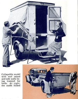
I’ve been a bit curious about the history of recreational vehicles in America and, last weekend, came across an article from the early days of vehicle camping, “Luxury Trailers create new army of Modern Gypsies,” published in the April 1936 issue of Popular Science.

I’ve republished the article , Modern Gypsies, as part of a reference library of vintage articles and articles I’ve written related to recreational vehicles.  At this point, though, the library is rather sparse, with only three articles.

Needless to say, the campers of 1936 differed greatly from many that we see today.  There are a lot of similarities, though, and a lot of innovation.  There are also “interesting” snippets:

Jack Bartlett, Tucson, Ariz., showman, recently purchased a trailer for $395, loaded into it a trained donkey weighing 800 pounds and a trunk containing fifty horned toads. With these as his performers, Bartlett tours the southwestern United States staging toad races and exhibitions of animal intelligence in hotel lobbies and schools.

An itinerant minister, traveling through sparsely settled sections of the West, has converted a house-type trailer into a portable church. He seats a dozen people, preaching from a small chapel and pulpit at one end. A woman evangelist, Mrs. Julia A. Locke, tours the country in her trailer, preaching from a platform while music is provided by a bungalow-type piano carried within.

The early days of work campers, I guess.

0 comments
None

Antelope Valley to Antelope Pass

From Antelope Valley road, we turned right on Forest Service road FS-135, heading for Copper Basin.

At the Antelope GS (Guard Station), FS-135 heads north up Bear Creek and Cherry Creek, then reaches windswept Antelope Pass.  The stretch of this road that climbs to Antelope Pass is narrow, winding, rutted, and can be very slick after rain.  A 4WD is recommended.  (Idaho: A Climbing Guide: Climbs, Scrambles, and Hikes (Climbing Guides) by Tom Lopez)

Heading toward Cherry Creek Summit:

Antelope Valley to Antelope Pass – Heading toward Cherry Creek Summit, July 25, 2010, Idaho Antelope Valley to Antelope Pass

Crossing Bear Creek Summit:Antelope Valley to Antelope Pass – July 25, 2010, Idaho, Crossing Bear Creek Summit

There were several aspen groves along the way:

Antelope Valley to Antelope Pass – -July 25, 2010, Idaho, There were several aspen groves along the way Antelope Valley to Antelope Pass

Antelope Pass looking back at the road we had just driven up:

Antelope Valley to Antelope Pass – July 25, 2010, Idaho, Antelope Pass looking back at the road we had just driven up

Antelope Pass, looking ahead into Copper Basin.

Antelope Valley to Antelope Pass – July 25, 2010, Idaho, Antelope Pass, looking ahead into Copper Basin.

Roughly triangular in shape, the central core of Copper Basin is an approximately 20,000-acre expanse of rolling sagebrush steppe, drained by the East Fork of the Big Lost River, Star Hope Creek, and numerous other named and unnamed waterways. Prairie potholes and erratic boulders near the valley’s heart are a reminder of the earth-shaping glaciers that once covered all of this land.  (Copper Basin by Jason Kauffman, Sun Valley Guide, Summer 2007)

Unfortunately, I didn’t get any more photos of Copper Basin.  We were driving through, on our way to Wildhorse Creek and, looking back, I wish we had done the Copper Basin Loop Road and gotten more pictures of this area.

0 comments
None

Antelope Valley

image On July 25, 2010, we headed a few miles north of Arco, Idaho to Antelope Valley (#6 on the map to the right, from a Lost River Valley Brochure from MackeyIdaho.com) on a back roads drive that would take us to Copper Basin (15), within 25 miles of Sun Valley, and to the foot of Idaho’s highest peak, Mt. Borah (17).  Note that the brochure map doesn’t show a “road” from Antelope Valley to Copper Basin, but there really is a way to drive there.

This particular area was a favorite when we lived in Idaho from 1977 to 1980.

Today’s images are from Antelope Valley.

Antelope Valley, Butte County, Idaho 2010 07 25 007panoed 2010 07 25 017panoed
0 comments
None

How to Get Traffic on the Internet

I just couldn’t resist sharing this one, especially since the author encourages use of his cartoons.

Maybe we need an eyecatching image to draw people to our site -  something that's exciting and cutting edge, and which represents all the endless possibilities that make the internet so powerful....Calamities of Nature, irreverent webcomics by Tony Piro
See more comics from Calamities of Nature

0 comments
None