Daffodils in January? – Crazy winter 2011/12.

2012 01 27 003Overall, for us, this winter has been crazily mild.  While, we did have one spell in December that was cold enough to brown much of the ground vegetation that normally stays green in this part of the country, it has been much warmer than normal for most of the season.

Still, it’s not normal to have daffodils in January, but we have the first blossom of the year – and the forecast is for temperatures above 60°F (15.5°C) for the week ahead.

So is winter over?  Where is all the cold weather? Is this global warming?

2011 02 10 b 027Winter’s probably not over here.  Typically, our snowiest month is February, followed by March, and we’ve even had snow in April, though some years we don’t get any snow at all. Last year, on February 9th, we had nearly a foot, and that was the second snow of the week.

On the other hand, spring-like conditions in early February 2008 led to a tornado outbreak that killed 13 in Arkansas (55 in southern US) with widespread damage and power outages.  I wouldn’t be surprised to see more big storms or winter weather in the next month, this year.

While it’s been unusually warm here,the reverse is true in other places.  Alaska has seen some brutally cold weather, worse than normal, and very heavy snow in places.  Sea ice in the Bering Sea is moving south much earlier than normal – and it’s moving fast, threatening to halt the snow-crap harvesting at the peak of the season.  Very cold temperatures and strong winds are pushing the ice south at 10 to 15 miles a day, 5 times the normal rate, threatening $8 million worth of crap pots and other gear already in the water.

In my view, our warmer weather and the colder weather in Alaska are just regional climate variations, not global warming or cooling, not a direct manifestation of climate change, though change is coming – it always is.

Globally,  temperatures have been relatively stable over the last decade.

While warming alarmists tout the decade as the warmest on record, “relatively stable” for more than 10 years isn’t warming.

As I’ve said in previous posts, my view is that we are on the verge of a significant drop in global temperature.  When it starts, if it starts, is anyone’s guess.  The loss of heat may have already begun in the waters of the world, without yet being felt in the weather.

One ominous prediction, though, says that the coming cold may move the geographical center of the corn producing region of North America from Iowa south into Kansas.

I’d rather have global warming.

What has the weather been like recently for you?
0 comments
None

Colorado National Monument.

Over the years, we’d been through Grand Junction at least 4 times, but had never stopped there or visited any of the local attractions.  After this trip, Colorado National Monument will certainly be a place we would like to visit again.

Colorado National Monument, established May 24, 1911, is located just to the west of Grand Junction.  Part of the larger Colorado Plateau, the monument features canyons that cut deep into sandstone and even granite formation.  It is high desert country, with elevation in the park ranging from 4000 feet to nearly 7000 feet above sea level.  Summer temperatures are usually very hot, while nighttime winter temperatures can be extremely cold.  Precipitation is limited, with an annual average of just over 10 inches..

The monument has a lot of hiking trails, with varying length and difficulty – we took two moderately long hikes during our visit, managing to wander off of the Devil’s Kitchen trail into and unmarked area.  We also took the Monument Canyon Trail from the upper trailhead to the Coke Ovens overlook and back.  The lower portion of the train from the lower trailhead to Independence Monument and back is highly recommended for visitors looking to do only one hike.  It’s a 2.5 mile hike that follows the base of sandstone cliffs, offering views of towering rock formations and, in the fall, it’s the best trail to see desert bighorn sheep.

Photos from Colorado National Monument have been published on the Exit78 facebook page in the “Colorado National Monument” album.


Selected Information Resources:

Karen’s Post  – Colorado National Monument

0 comments
None

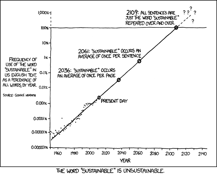
Sustainable

Sometimes the overuse of words make them unsustainable and actually reduces their impact.


This work, at http://xkcd.com, is licensed under a Creative Commons Attribution-NonCommercial 2.5 License.
This means you’re free to copy and share these comics (but not to sell them). More details.

0 comments
None

Grand Junction and Art on the Corner.

2011 09 17 b 171As we had a few days before our next reservation – Arches National Park, – we decided to stop in an area we had only passed through before, Grand Junction, Colorado.  While we were there, we took a stroll down Main Street and discovered Grand Junction’s “Art on the Corner.”

While at Grand Junction, we also visited Colorado National Monument and The Museum of Western Colorado.

The name “Grand” is derived from the Grand River, the name for the upper Colorado River before it was renamed in 1921.  “Junction” is from the joining of the Colorado and Gunnison rivers, just southwest of the downtown area.


Selected Information Resources:

Grand Junction.

Museum of Western Colorado

0 comments
None

Cooling or Warming? (another test of settings)

I’m running another test of the settings of the plugin to send posts to facebook.

UAH_LT_1979_thru_December_2011The figure provided with this test is a trend of satellite determined temperature variation for the lower atmosphere of the entire planet.  The figure is published monthly.  The temperature variation (or anomaly) is plotted as a temperature departure from the average value from January 1981 to December 2010.

The high peaks of the running 13 month average at 1998 and 2009 occurred from periods with strong El Ninos.  The drop at the end of the figure corresponds to La Nina periods

0 comments
None

Eruption over on new Red Sea island? – Update.

It looks like the eruption on the new Red Sea Island has stopped, at least for the time being.

Previous Posts on the New Island:

image

The new island is part of the Zubair Islands, located about 40 miles off the coast of Yemen.  It is about 3,300 feet long and about 1,650 feet wide.  This NASA image is from January 15.

Other volcano related news.

In Ethiopia, a party of tourists visiting Erta Ale volcano were attacked by gunman in the middle of the night at a camping spot on the crater rim.  At least 5 were killed and several taken hostage. The 5 dead victims were from Germany (2), Hungary (2), and Austria (1).  Two Germans and two Ethiopians were abducted.  Seven other tourists were wounded.  They were from Germany, Italy, Hungary, and Ethiopia.  The gunmen were said to be a group of rebels from Eritea.

0 comments
None

Linking a blog to facebook.

rant_raven

This is a second test of the feed from by blog to facebook.  It’s not intended to be a tutorial on how to set up a feed, though there may be some useful information for doing that.

There are a number of different ways to provide a feed from a blog to your facebook page (wall).

This is what worked for me.

However, that isn’t exactly what I wanted to do.  I wanted to the info to go to a page associated with my blog, not my personal facebook page.  I didn’t realize that I had to find something that would do that until after I had installed a WordPress plugin that would only send the post to a personal facebook wall.

Facebook Page Publish.

The second try was a plugin called Facebook Page Publish.  After installing the plugin, it took me a bit to find the link to its settings page.  Instead of being on the plug-ins menu, its under the Settings menu.

imageTo connect the blog to facebook with this plugin, you have to create an app.  To get to the menu for building an app, use this link, or, if that didn’t work,

  • go to the menu at the bottom of your facebook page and select Developers – or use this link.
  • then at the top of the developers page, select the link for apps .

This post is intended to be a second test of the feed from my blog to facebook.  It’s not intended to be a detailed tutorial on how use the App feature or the WordPress plugin, so this is as far as I’ll go with it.

0 comments
None

Adding Facebook page with feed (if this works).

Many bloggers are now sometimes bloggers or former bloggers who I see more on facebook than on their blog or commenting in their blog.

So, now, I’m going to try to integrate facebook with my blog.

If this post stays here, it worked.  If it didn’t work, this post won’t be here, except in short term internet memory.

image
0 comments
None

High Mountains to High Desert.

Leaving Rocky Mountain National Park on September 16, 2011, our next destination was several thousand feet lower and on the western side of the state – Grand Junction, Colorado.

St. Catherine of Siena Chapel at St. Milo Retreat, Allenspark, Colorado; Chapel on the RockAbout nine miles south of Estes Park on Colorado 7, we stopped to take pictures of the Chapel on the Rock – officially St. Catherine of Siena Chapel – on the grounds of Saint Malo Retreat Center.   The chapel  is built on an large piece of granite that the Colorado highway department once planned to dynamite to widen and straighten the adjacent highway.  Dedicated in 1936, the chapel was built from local stone hauled in by mule carts.

In November 2011, a fire heavily damaged portions of the St. Malo Retreat Center.  The chapel, several hundred feet away was not damaged.

2011_trip_map_5th_leg

Our drive for the day was about 300 miles.  The first part was on mountain 2-lane highways down to Interstate 70.  Traffic was quite light, certainly less than it would have been if we had gone through Boulder and along the foothills of the Front Range as we did in 2009.

I70 meanders up, down, around and through the Colorado mountains between Denver and and Grand Junction.  Our little motorhome did pretty good duty traveling over this road once again, though the CRV it was towing was 6 model years newer than the last time.

“The Eisenhower Tunnel, with a maximum elevation of 11,158 feet (3,401 m) and length of 1.7 miles (2.7 km), is the longest mountain tunnel and highest point along the Interstate Highway System.” (Wikipedia.)

We stopped in Vail for lunch and a stretch break.  Often, when there isn’t a rest area handy, we’ll take a break after an hour or two of driving by stopping at a “big box” store.  Most of them are large enough that we can loosen up by taking a couple of laps walking around inside the store.  In Vail, we stopped at WalMart and, once we were loosened up, went back out to the camper and had lunch in our camper.

Navion IQ, Honda CRV in Glenwood Canyon Colorado.Our next stop was a  rest area in Glenwood Canyon, a rugged and scenic canyon on the Colorado River. This area is one of the most scenic natural features along the U.S. Interstate Highway System.  Foot access is available for hiking a four rest areas in the canyon.  The highway through the canyon was one of the final pieces of the system to open to traffic and was one of the most expensive per mile constructed in the United States.  In its 12.5 mile length, there are three tunnels, 40 bridges and viaducts, and miles of retaining walls.  “Through a significant portion of the canyon, the eastbound lanes extend cantilevered over the Colorado River and the westbound lanes are suspended on a viaduct several feet above the canyon floor.” (Wikipedia)

The trip along I 70 was a gradual transition from high mountain forests and tundra west of Denver to the high desert of western Colorado and Utah.

We would be camping in the Grand Junction, 4,593 ft (1,397 m), area for the next 4 nights and would be in desert country for a good portion of the rest of the trip.

1 comment
None

Elk Viewing Season in Moraine Park.

2011 09 12 440for blogWe visited Rocky Mountain National Park in September, largely because it’s the prime period for viewing North American elk (wapiti) in the park.

In late summer and early autumn, elk descend from the high country to mountain valley meadows for the annual mating season.  Bull elk compete with each other for the right to breed with a herd of females.  Although the competition is high, it’s mostly posturing for the females as actual fighting results in injury and depletes energy.

One of the best – and most popular –  areas for viewing the elk is Moraine Park.  The word “park” used in place names in the Colorado Rockies often refers to a valley or meadow.  In this instance, Moraine Park is a long, glacier formed valley, with broad meadows at the lower end.

2011 09 12 421 image for blogA moraine is a accumulation of boulders, stones and other debris deposited by a glacier.  Aptly named Moraine Park is bounded by moraines on three sides.  On the north and south, the valley is enclosed by lateral moraines, formed when the glacier deposited debris along its side.  Debris at the east end of the valley formed a terminal moraine against a small mountain.

A two lane paved road to the Fern Lake trailhead runs along the south side of the Moraine Park meadow.  In the cool evenings of the elk mating season, portions of the road are often jammed with cars and pedestrians watching the elk – what we like to call a “critter jam.”

While we were down along Fern Lake Road several evenings to view the elk, we didn’t take our car.  We could have taken the hiker shuttle bus, but didn’t do that either.  Instead, we walked.

Moraine Park campground is situated on the northern lateral moraine and there is a trail that goes down the hill to the meadow.  When we visited in 2009, our campsite was right next to the trail, but, this year, that site was, unfortunately, reserved, so we had to settle for a site a little further away.


Selected Information Resources:

Rocky Mountain National Park
Estes Park
Grand Lake
0 comments
None