 There are larger rivers in Arkansas. Some carried more commerce, powered more industry, and played a larger role in the state’s settlement.
But there is nothing quite like the Buffalo.
Running through some of the roughest country in the Arkansas Ozarks, the Buffalo River winds beneath towering limestone and sandstone bluffs, past abandoned farms and old mining settlements, through deep forest and isolated valleys, and eventually into the White River.
For most of its existence, nobody considered it a national treasure.
It was simply the river.
Families lived beside it. They planted corn in its bottoms, raised livestock on its hillsides, cut timber from the surrounding forests, dug zinc and lead from the mountains, fished its pools, crossed it on horseback and in wagons, and sometimes watched helplessly as floods swept away what they had built.
Then, in the twentieth century, Americans began to see rivers differently.
Across the country, people dammed rivers for electricity, flood control, navigation, and recreation. The Buffalo appeared destined for the same fate.
Instead, Arkansans fought over it.
The fight lasted years.
And in the end, the Buffalo became something entirely new: America’s first national river.
A River Born in the Boston Mountains
The Buffalo begins high in the Boston Mountains of northwestern Arkansas, among the Ozarks’ highest and most rugged country.
From there it generally flows eastward across northern Arkansas before joining the White River.
Today, approximately 135 miles of the Buffalo are protected within Buffalo National River. The National Park Service manages roughly 94,000 acres associated with the river corridor.
But those numbers do not really describe the Buffalo.
The river’s character changes dramatically from one end to the other.
 In its upper reaches around Boxley, Ponca, Steel Creek and Kyles Landing, the Buffalo behaves almost like a mountain stream. The gradient is steeper, the current faster, and the surrounding country spectacularly rugged. After heavy rain, water pours from side hollows and over cliffs. Rapids alternate with long pools beneath immense bluff lines.
Farther downstream, the river gradually broadens and slows. Gravel bars become more prominent. The surrounding cliffs remain impressive, but the river assumes a different personality as it works its way toward the White.
This variety is what makes traveling the Buffalo so remarkable. A person can spend several days floating downstream and watch the landscape change around him.
The river doesn’t simply pass through the Ozarks.
The river helped create the Ozarks we see today.
A Landscape Carved by Water
The Buffalo River country is built largely from ancient sedimentary rocks—sandstone, limestone, and dolomite deposited hundreds of millions of years ago.
Water has worked on those rocks ever since the Ozark Plateau uplifted and erosion began cutting into it.
The result is an extraordinary landscape.
In places, bluffs rise more than 400 feet above the river. Caves penetrate the limestone. Springs emerge unexpectedly from hillsides. Sinkholes, disappearing streams, rock shelters, waterfalls, and narrow hollows are scattered throughout the watershed.
More than 500 caves are known within Buffalo National River, making it one of the National Park Service’s most cave-rich units.
The same geology also created the enormous bluff shelters that became important to people thousands of years ago.
Hemmed-in Hollow offers one of the landscape’s most spectacular examples. After sufficient rainfall, water drops nearly 210 feet from the bluff, creating one of the tallest waterfalls between the Appalachian and Rocky Mountains.
 Then there is Big Bluff, Roark Bluff, Painted Bluff, and countless unnamed cliffs and formations that seem to appear around every bend.
This scenery is difficult to appreciate from a highway.
The Buffalo is best understood from the river itself.
People Were Here Long Before Arkansas
The Buffalo River’s history did not begin with white settlement.
People occupied the Ozarks thousands of years before Arkansas became a state. Archaeological evidence documents human presence in the region reaching back to the Paleoindian period.
Generations of Native people used the river valleys, terraces, caves, and bluff shelters. Over thousands of years, changing cultures hunted, gathered plants, established settlements, and eventually practiced agriculture in and around the Buffalo watershed.
By the historic period, several Native peoples had connections with northern Arkansas, including the Osage, Cherokee, and Shawnee.
European-American settlement reached the Buffalo River country in the early nineteenth century, as it did across much of Arkansas after the Louisiana Purchase.
In that respect, the Buffalo was not unusual. Much of Arkansas was still sparsely settled, poorly connected by roads, and difficult to reach during the territorial period.
What distinguished the Buffalo country was how its terrain continued to shape settlement after people arrived. The steep ridges, narrow valleys, rocky uplands, and frequent stream crossings limited where farms could be established and made transportation unusually difficult. Families concentrated in the relatively small areas of fertile bottomland along the Buffalo and its tributaries, while settlements remained scattered across the surrounding hills.
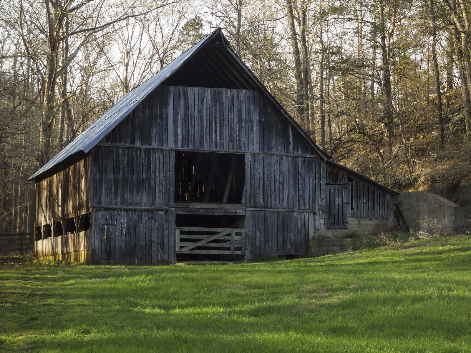 The difficulty was therefore not simply settlers getting into the country. It was building farms, communities, roads, and market connections in a landscape with little level ground and few easy routes.
Making a Living Along the Buffalo
For much of the nineteenth and early twentieth centuries, life beside the Buffalo was not romantic.
It was work.
Families cleared fields with hand tools and animal power. Corn was one of the essential crops because it could feed both people and livestock. Gardens, hogs, chickens, cattle, and hunting supplemented what a family could grow.
Small communities formed around schools, churches, mills, and stores.
Because transportation was difficult, many families had to produce much of what they consumed.
Cash was often scarce.
That did not mean the people of the Buffalo country were completely isolated from the outside world. Timber, minerals, and agricultural products connected them to regional markets. But geography imposed a cost on nearly everything.
Getting something into the Buffalo country could be difficult.
Getting something out could be even harder.
Remnants of that life remain throughout the national river today.
Old cabins stand beside fields slowly being reclaimed by forest. Stone walls disappear into the undergrowth. Cemeteries remain on hillsides after the communities that created them have vanished.
 Places such as the Parker-Hickman Farmstead and the Collier Homestead preserve something easily overlooked when admiring the scenery:
The Buffalo River was somebody’s home long before it became somebody else’s vacation.
War Comes to the Mountains
The Civil War reached Buffalo country differently than it reached places like Pea Ridge, Prairie Grove, or Helena.
No great armies maneuvered continuously along the river.
Instead, much of the violence came from smaller military detachments, guerrillas, bushwhackers, and irregular bands.
Northern Arkansas became a dangerous place.
Loyalties were divided. Either side could take food and livestock. Men disappeared into military units or irregular bands. Families could become targets because of suspected sympathies.
The rugged isolation of the Buffalo country, normally an inconvenience, could conceal armed groups.
The war’s effects continued after the major armies left.
Farms had been neglected or destroyed. Livestock disappeared. Families had been scattered.
Recovery was slow.
Timber, Mines and the Outside World
By the late nineteenth century, the industrial world increasingly reached into the Buffalo country.
Timber companies recognized the value of the Ozark forests.
Portable sawmills let crews move closer to timber rather than haul every log long distances to a permanent mill. Logging became an important source of cash income for families accustomed to subsistence farming.
Mineral production sparked an even more dramatic boom.
In the 1880s, people discovered zinc deposits around Rush Creek near the lower Buffalo.
What followed transformed an isolated Ozark valley.
Claims were filed. Mines opened. Investors arrived. Processing operations were constructed. Stores and houses appeared.
Rush became a mining town.
The largest operation, the Morning Star Mine, began in the 1880s. Eventually, numerous mining companies operated in the district.
World War I brought the boom to its peak.
Zinc was important for producing brass, which was in high demand for wartime manufacturing. Mining expanded rapidly, and Rush became one of Arkansas’s significant zinc-producing centers.
For a brief period, thousands lived in the district.
Then the boom collapsed.
Zinc prices fell after the war. Mines closed. People left.
The Morning Star Mine ceased operations in 1931, though later attempts were made to revive mining.
Today Rush is one of the most fascinating cultural landscapes within Buffalo National River.
What remains is neither completely a town nor completely a ruin.
Old buildings, foundations, mine openings, and traces of roads survive among the trees.
The forest is reclaiming the valley.
Depression in the Ozarks
For rural Arkansas, economic hardship did not suddenly begin with the stock market crash of 1929.
Farm prices had already fallen. Floods and drought caused additional damage. Much of rural Arkansas was already poor when the Great Depression hit.
The Buffalo River country was no exception.
New Deal programs eventually reached even these isolated valleys.
The Civilian Conservation Corps became particularly important.
 Beginning in 1938, CCC workers developed what became Buffalo Point, building roads, trails, recreational facilities and structures whose craftsmanship remains visible today.
It was an interesting transition.
For generations, Americans viewed wild country primarily in terms of what they could extract from it—timber, minerals, farmland, or water power.
Now the federal government began investing money in preserving and enjoying landscapes itself.
That change in thinking would eventually determine the fate of the Buffalo River.
The Dam That Was Never Built
By the mid-twentieth century, dam building represented progress in much of America.
The Army Corps of Engineers and other federal agencies had transformed rivers throughout the country.
Dams promised flood control, hydroelectric power, reservoirs, and economic development.
The Buffalo seemed like another logical candidate.
Proposals for dams on the river emerged, particularly during the 1950s and early 1960s.
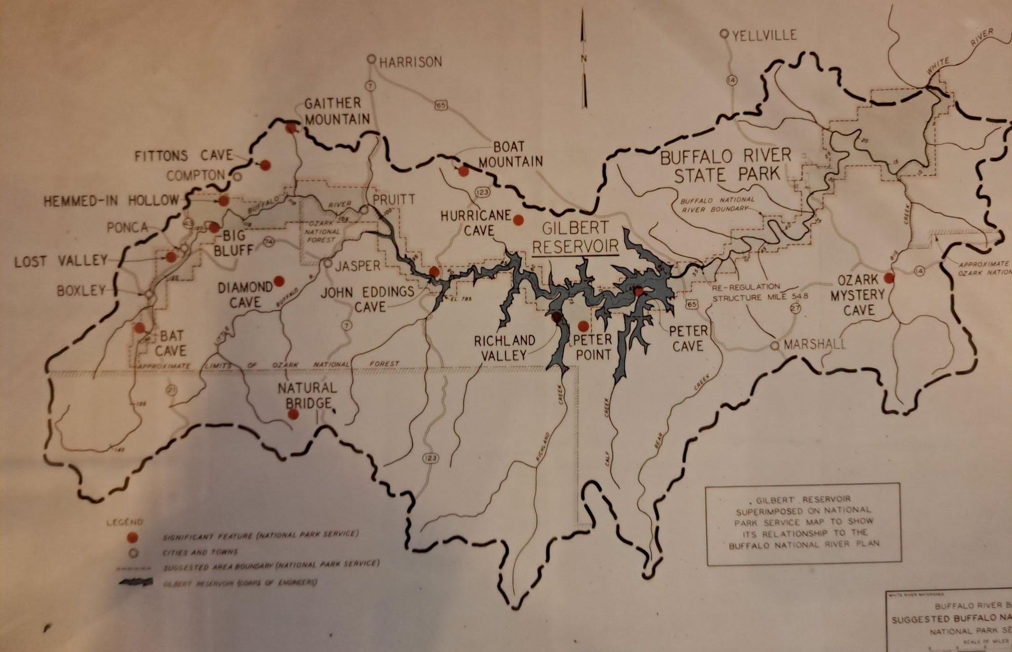 Supporters argued that reservoirs would bring development and recreational opportunities to one of Arkansas’s poorer regions.
We should not dismiss their argument as simple hostility toward nature.
Many residents genuinely believed a dam could bring jobs, money, and opportunity to an area that had struggled economically for generations.
But others saw something very different.
A dam would destroy the Buffalo as a free-flowing river.
The deep valleys that made reservoirs possible were precisely the valleys that made the river extraordinary.
The argument became one of Arkansas’s most important conservation fights.
Neil Compton and the Ozark Society
Dr. Neil Compton of Bentonville was among the leading opponents of the dams.
Compton was a physician, photographer, outdoorsman, and passionate advocate for the Ozarks.
He and others helped organize the Ozark Society in 1962.
Their objective was straightforward:
Save the Buffalo River.
The campaign combined photography, public speaking, political organizing, newspaper coverage, and something particularly effective—taking influential people onto the river itself.
After floating beneath its bluffs, it was difficult to regard the Buffalo as merely another potential reservoir site.
One of the most famous visitors was U.S. Supreme Court Justice William O. Douglas, already nationally known for his interest in conservation.
The controversy increasingly attracted attention beyond Arkansas.
The National Park Service studied the river and recommended protecting it as a new type of park—a national river.
Arkansas politics began to shift.
In December 1965, Governor Orval Faubus informed the Corps of Engineers that he could not support damming the Buffalo.
The dam proposal collapsed.
But preventing the dam did not guarantee permanent protection.
That required Congress.
America’s First National River
Political support gradually grew for federal protection.
Congressman John Paul Hammerschmidt, along with Arkansas senators J. William Fulbright and John L. McClellan, played important roles in moving legislation forward.
After years of debate, Congress acted.
On March 1, 1972, legislation creating the Buffalo National River was signed into law by President Nixon
For the first time in American history, Congress created a national park unit specifically designed to preserve a free-flowing river.
That distinction matters.
The Buffalo was not preserved simply because somebody thought the scenery was pretty.
It represented a fundamentally different idea about rivers.
A river did not have to be dammed to be useful.
A river could have value because it remained a river.
A Wild River—but Not an Empty One
One of Buffalo National River’s great strengths is that it protects both nature and human history.
The park contains prehistoric archaeological sites, pioneer farms, cemeteries, mining ruins, historic cabins, CCC structures, and the remains of communities that once seemed permanent.
 The river flows through it all.
In some places, nature is slowly erasing the evidence.
A field becomes cedar and hardwood forest.
A road becomes a trail.
A foundation disappears beneath leaves.
A community name survives on a map after almost every building is gone.
That process gives the Buffalo a character different from a landscape that has never been inhabited.
It is wilderness layered over history.
The Return of the Elk
One of the most visible modern residents of the Buffalo country is actually a returnee.
Elk once lived in Arkansas but disappeared during the nineteenth century as a result of hunting and habitat changes.
In 1981, the Arkansas Game and Fish Commission began restoring elk to the Buffalo River region, releasing Rocky Mountain elk into the area.
The animals thrived.
 Today, elk can commonly be seen in and around the Boxley Valley, particularly early in the morning and near evening.
During the autumn rut, the bugle of a bull elk across an Ozark valley produces a sound that would have been familiar to people in North America centuries ago but had been absent from Arkansas for generations.
The restoration has become one of Arkansas’s most successful wildlife stories.
Floating the Buffalo
For many Arkansans, the Buffalo is inseparable from canoeing.
Floating remains the best way to understand the river because roads rarely follow it closely.
That is important.
Many scenic rivers have highways running beside them. The traveler never completely escapes automobiles, pavement, and development.
Much of the Buffalo is different.
Once around a few bends, roads can disappear.
The upper Buffalo around Ponca and Steel Creek offers perhaps the river’s most dramatic scenery. Roark Bluff rises above Steel Creek, and the Steel Creek-to-Kyles Landing section passes through an extraordinary succession of bluffs, rapids, pools and side canyons.
 The middle river offers longer stretches suitable for multi-day travel.
The lower river broadens and often becomes more dependable when the upper river becomes too shallow to float.
But the Buffalo should never be mistaken for an amusement-park ride.
Water levels change quickly.
Floods can transform a quiet river into something extraordinarily powerful. Cold water, strainers, submerged obstacles, and remote locations can create serious hazards.
Its freedom is part of its beauty.
Visitors must also respect it.
More Than a River
Today, the Buffalo National River encompasses far more than the channel itself.
There are more than 100 miles of hiking trails.
Three designated wilderness areas—the Upper Buffalo, Ponca, and Lower Buffalo wildernesses—protect some of the river’s wildest country.
Visitors hike to Big Bluff, Hemmed-in Hollow, Indian Rockhouse and historic farmsteads. Others camp, fish, ride horses, watch elk or simply sit beside the water.
At night, another feature becomes apparent.
Darkness.
Large portions of the Buffalo corridor remain far removed from major cities and their artificial light. Stars that disappear above urban America remain clearly visible above the river.
Yet despite all the recreational opportunities, the greatest attraction remains the simplest one.
The river is still running.
What Was Saved
It is easy today to assume that the Buffalo was somehow destined to become a national river.
It wasn’t.
Had a few political decisions gone differently in the 1950s and 1960s, portions of the Buffalo River valley might now lie beneath reservoirs.
Places whose names generations of floaters know might exist only on old maps.
The bluffs would still be there, but their bases might stand beneath still water.
The gravel bars would be gone.
The rapids would be gone.
The river itself would be gone.
Something else would have replaced it.
Perhaps that is why the Buffalo remains one of the clearest examples of what conservation actually means.
Conservation is not merely admiring something beautiful after someone else has protected it.
Sometimes somebody has to decide, while destruction is still a perfectly realistic option, that a place is worth keeping.
Arkansans made that decision about the Buffalo.
The River That Remained a River
The Buffalo has flowed through the Ozarks for a length of time almost impossible to comprehend.
Human beings arrived beside it thousands of years ago.
Native peoples hunted and lived along it.
Settlers cleared farms beside it.
Soldiers and guerrillas crossed its valleys.
Loggers cut its forests.
Miners dug into its mountains.
Children attended one-room schools beside tributary roads.
CCC crews built recreational areas.
Engineers planned dams.
Conservationists paddled canoes beneath the bluffs and argued that some rivers should remain rivers.
Congress eventually agreed.
More than half a century after the creation of Buffalo National River, the water still runs from the Boston Mountains toward the White.
It floods.
It falls.
It rises again.
Gravel bars move. Trees fall. Bluffs weather. Springs continue pouring from limestone.
The Buffalo remains untamed enough to remind us that not everything valuable needs improvement.
Sometimes the greatest thing one generation can do for the next is simply refuse to destroy what was already there.


