Selected photos from a trip in the western U.S. in 2007. Audio track: Paul Mottram’s “Sidewalk Saunter.”
Exit78
Black Sand Beach
June 15, 201721st Century Digital #19

Punalu’u Black Sand Beach on the Big Island, Hawaii. 2005. December 6.
Carol M. Highsmith’s America, Library of Congress, Prints and Photographs Division.
Photograph retrieved from the Library of Congress, www.loc.gov/item/2010630043/. (Accessed March 05, 2017.)
Photograph: Carol M. Highsmith
Medium: 1 photograph : digital, TIFF file, color.
Highsmith, a distinguished and richly published American photographer, has donated her work to the Library of Congress since 1992. Starting in 2002, Highsmith provided scans or photographs she shot digitally with new donations to allow rapid online access throughout the world. Her generosity in dedicating the rights to the American people for copyright free access also makes this Archive a very special visual resource.
Note – This image has been digitally adjusted for one or more of the following:
– fade correction,
– color, contrast, and/or saturation enhancement
– selected spot and/or scratch removal
– cropped for composition and/or to accentuate subject matter
– straighten image
See on Flickr
Punalu’u Beach (Wikipedia)
Strike
June 14, 2017Sign, Sign, Everywhere a Sign #15

New York City employees picket City Hall
1954 World Telegram photo by Dick DeMarsico.
Teamster Union members holding picket signs supporting higher raises and pensions.
Photograph retrieved from the Library of Congress, www.loc.gov/pictures/item/00652480/. (Accessed April 02, 2017.)
Forms part of: New York World-Telegram and the Sun Newspaper Photograph Collection (Library of Congress).
See my Sign, Sign, Everywhere a Sign video on YouTube!
Note – This image has been digitally adjusted for one or more of the following:
– fade correction,
– color, contrast, and/or saturation enhancement
– selected spot and/or scratch removal
– cropped for composition and/or to accentuate subject matter
– straighten image
A Visit to Great Falls, Montana
June 10, 2017While we had been here before, in 2001, we had just been passing through on our way to Glacier National Park and had made reservations at a hotel in Great Falls for one night.
In the images used for this video, though, Great Falls was a 2007 destination for a family visit. A brother, his wife and two sons were living there. While visiting with family, we also saw some of what is left of the falls, went to a farmers’ market, saw an autocross competition, visited Giant Spring State Park, spent a little time at a horse auction and stopped at the Lewis & Clark National Historic Trail Interpretive Center.
__________
References for Great Falls:
Thank You Sid
June 8, 201721st Century Digital #18

Jimmy Stewart’s hand and footprints, Grauman’s Chinese Theatre, Los Angeles, California. 2006. July 3.
The grand opening of Grauman’s Chinese Theatre in Hollywood on May 18, 1927, was the most spectacular theatre opening in motion picture history. Thousands of people lined Hollywood Boulevard and a riot broke out as fans tried to catch a glimpse of the movie stars and other celebrities as they arrived for the opening. The film being premiered that night was Cecil B. DeMille’s The King of Kings,’ which was preceded by “Glories of the Scriptures,” a live prologue devised by master showman Sid Grauman. A Wurlitzer organ and 65-piece orchestra provided music for the prologue. The theatre opened to the public the following day, May 19, 1927. Protected by its 40-foot high curved walls and copper- topped turrets, the theatre’s legendary forecourt serves as an oasis to the stars of yesterday and today. Ten-foot tall lotus-shaped fountains and intricate artistry flank the footprints of some of Hollywood’s most elite and welcome its visitors into the magical world of fantasy and whim known as Hollywood. (Library of Congress)
Photographer: Carol M. Highsmith
Medium: 1 photograph : digital, TIFF file, color.
Retrieved from the Library of Congress, http://www.loc.gov/pictures/item/2010630039/. (Accessed March 02, 2017.)
See more on Flickr.
The Hollywood Sign
June 7, 2017Sign, Sign, Everywhere a Sign #14

The Hollywood Sign as it appears from a trail in the Hollywood Hills in Hollywood, California
November 5th, 2006
Wikipedia: The Hollywood Sign (formerly the Hollywoodland Sign) is a landmark and American cultural icon located in Los Angeles, California. It is situated on Mount Lee, in the Hollywood Hills area of the Santa Monica Mountains. The sign overlooks Hollywood, Los Angeles.
“HOLLYWOOD” is spelled out in 45-foot (13.7 m)-tall white capital letters and is 350 feet (106.7 m) long. It was originally created in 1923 as an advertisement for a local real estate development, but it garnered increasing recognition after the sign was left up.[2] The sign was a frequent target of pranks and vandalism, but it has since undergone restoration, including the installation of a security system to deter vandalism. The sign is protected and promoted by The Trust For Public Land, a nonprofit organization, while its site and the surrounding land are part of Griffith Park.
From the ground, the contours of the hills give the sign a wavy appearance. When observed at a comparable altitude, the letters appear nearly level.
The sign makes frequent appearances in popular culture, particularly in establishing shots for films and television programs set in or around Hollywood. Signs of similar style, but spelling different words, are frequently seen as parodies. (See more at Wikipedia)
Photo by Oreos (Own work) [GFDL, CC-BY-SA-3.0 or CC BY-SA 2.5-2.0-1.0], via Wikimedia Commons 5 November 2006

Accessed March 2017
See my Sign, Sign, Everywhere a Sign video on YouTube!
Note – This image has been digitally adjusted for one or more of the following:
– fade correction,
– color, contrast, and/or saturation enhancement
– selected spot and/or scratch removal
– cropped for composition and/or to accentuate subject matter
– straighten image
Beartooth Highway–Montana and Wyoming
June 3, 2017(Music: Land of Promise, Terry Devine King, Royal Philharmonic Orchestra, YouTube Audioswap)
We camped for two nights at a campground just outside of Billings, Montana on our 2007 late summer trip. We hadn’t decided on what to do or where to go on our “non-travel” day. Looking at the map, the Beartooth Highway looked like it might be interesting. While it was a ways to go, we decided to check it out.
In hindsight, I have only one regret for taking the drive that day and it’s only that I wished we were camped closer to the beginning of the climb into the Beartooth Mountains, perhaps somewhere around Red Lodge, where the Beartooth Highway begins. Other than that, the drive, said by some to be “the most beautiful drive in America,” was well worth it.
From Wikipedia:
The Beartooth Highway is the section of U.S. Highway 212 between Red Lodge, Montana and Cooke City, Montana. It traces a series of steep zigzags and switchbacks, along the Montana-Wyoming border to the 10,947 ft (3,337 m) high Beartooth Pass. The approximate elevation rise is from 5,200 ft (1,600 m) to 8,000 ft (2,400 m) in 12 mi (19 km) in the most daring landscapes.
When driving from the east to the west, the highest parts of the Beartooth Highway level off into a wide plateau near the top of the pass, and then descend to where the Beartooth Highway connects to the Chief Joseph Scenic Byway near Cooke City, which forms the northeast gateway to Yellowstone National Park. En route, one passes numerous lakes typical of the Absaroka-Beartooth Wilderness Area which borders the highway along much of its route.
The highway officially opened June 14, 1936.
Beartooth Highway references:
- The Beartooth Highway
- Wikipedia
- Travel Channel
- Beartooth Mountains – Wikipedia
- Beartooth Ranger District – US National Forest Service
Spring Blossoms on the Potomac
June 1, 201721st Century Digital #17

Washington Monument, Washington, D.C. 2007. April 2.
Photographer: Carol M. Highsmith
Medium: 1 photograph : digital, TIFF file, color.
Retrieved from the Library of Congress, http://www.loc.gov/pictures/item/2010630035/. (Accessed March 03, 2017.)
See more on Flickr.
Hammel Illinois on Route 66
May 31, 2017Sign, Sign, Everywhere a Sign #13

Entrance sign to Hamel, Illinois, Route 66. 2009.
Hamel is where the two Metro East alignments of Route 66 part ways, the earlier path heading through Edwardsville and Mitchell towards the Chain of Rocks Bridge and the Show Me State. The later corridor heads further south towards Troy and Collinsville before heading into Missouri from East Saint Louis.
Photograph retrieved from the Library of Congress, www.loc.gov/pictures/item/2010630493/. (Accessed April 03, 2017.)
Highsmith, Carol M, photographer.
Medium: 1 photograph : digital, TIFF file, color.
Call Number: LC-DIG-highsm- 04508 (ONLINE) [P&P]
Notes:
Title, date, and subjects provided by the photographer.
Credit line: Carol M. Highsmith’s America, Library of Congress, Prints and Photographs Division.
Gift and purchase; Carol M. Highsmith; 2009; (DLC/PP-2010:031).
Forms part of: Carol M. Highsmith’s America Project in the Carol M. Highsmith Archive.
Highsmith, a distinguished and richly published American photographer, has donated her work to the Library of Congress since 1992. Starting in 2002, Highsmith provided scans or photographs she shot digitally with new donations to allow rapid online access throughout the world. Her generosity in dedicating the rights to the American people for copyright free access also makes this Archive a very special visual resource.
See my Sign, Sign, Everywhere a Sign video on YouTube!
Note – This image has been digitally adjusted for one or more of the following:
– fade correction,
– color, contrast, and/or saturation enhancement
– selected spot and/or scratch removal
– cropped for composition and/or to accentuate subject matter
– straighten image
Devils Tower
May 27, 2017America’s First National Monument
This was our second visit to Devils Tower. Our first was an abbreviated, quick visit-and-get back-on-the-road side trip on our way home from a western vacation. On this 2007 visit, we stayed 3 nights at the Devils Tower KOA campground, just outside the entrance station to the monument. One of the trails that we took was a trail that goes all the way around the base of Devils Tower.
|
Devils Tower is a sacred site to many American Indian tribes. All along the trail could be seen Indian prayer offerings (bundles and cloths). The other trail we took was a full moon hike with a park ranger. I did have a couple of good images that turned out from that night, but they were from after we got back to the camper. One of them is the last image of the video slide show at the beginning of this post. Photos (from top to bottom):
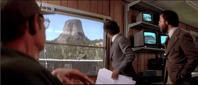
It’s interesting, now, how familiar much of the scenery in the movie is now, including some of the scenery outside the park. The area where the military encampment is shown to be in the movie is now the site of several better than average touristy type shops. |
    |
Devils Tower (Lakota: Mato Tipila, which means “Bear Lodge”) is a monolithic igneous intrusion or volcanic neck located in the Black Hills near Hulett and Sundance in Crook County, northeastern Wyoming, above the Belle Fourche River. It rises dramatically 1,267 feet (386 m) above the surrounding terrain and the summit is 5,112 feet (1,558 m) above sea level.
__________
Devil’s Tower references:


