A Sunny Autumn Teton Day


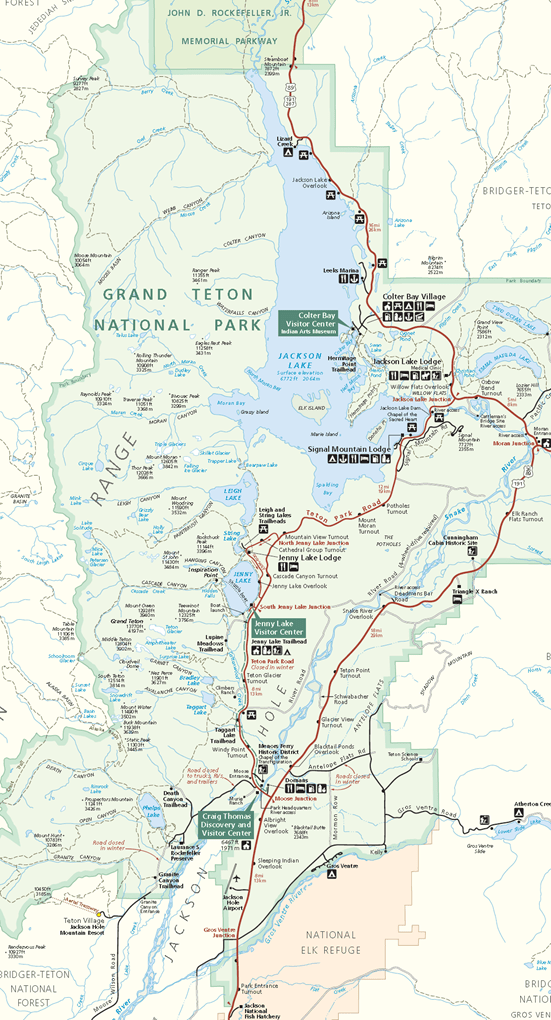
Even though we had been to Grand Teton National Park many times before, on this trip we explored some areas we had not been to before in the southeastern part of the park and just outside, in the Gros Ventre and Antelope Flats areas. They which yielded quite few opportunities for photographs from viewpoints different from what I had taken in the past including old log structures and the Mormon Row settlement.

Other photos include a large plane landing at Jackson against Grand Teton as a backdrop, Jackson lake, Signal Mountain, Chapel of the Transfiguration, moose resting along the Snake River near the Moose entrance to the park; Menor’s Ferry, Bill Menor’s cabin and store, and aspen fall colors.

__________

References and Resources:

0 comments
None

Grand Teton National Park, September 19, 2007

tetons2Separated from Yellowstone National Park by only 10 miles, Grand Teton National Park is another of our favorites that we have visited many times.  Though we have camped in the park on some previous visits, this time we stayed at a campground on the Snake River south of Jackson, Wyoming.

The park is named for Grand Teton, the tallest peak, 13,775 feet (4,199 m),  in the Teton Range, which rises abruptly above the valley of Jackson Hole.

Jackson Hole is believed to be named after a mountain man, David (Davey) Edward Jackson, a mountain man who trapped the area for beaver in the early 1800s.  The name “hole” is a term used by early trappers who entered from the north and east, descending along relatively steep slopes, giving the feeling of descending into a hole.

The town of Jackson, Wyoming, the only incorporated town in the valley, is often mistakenly referred to as Jackson Hole.

__________

References and Resources:

0 comments
None

Upper Mesa Falls, Idaho

September 16, 2007

On one of the days we were camped near West Yellowstone, Montana, we decided to take a drive into Idaho.  The high point of the drive was the Mesa Falls Recreation Area.

From Wikipedia:

Upper Mesa Falls is a waterfall on the Henrys Fork in the Caribou-Targhee National Forest. Upstream from Lower Mesa Falls, it is roughly 16 miles away from Ashton, Idaho.

Upper Mesa Falls is roughly 114 feet high and 200 feet wide.[2]

Formation

Mesa Falls Tuff, which is the rock over which Upper Mesa Falls cascades, was formed 1.3 million years ago. A cycle of rhyolitic volcanism from the Henrys Fork caldera deposited a thick layer of rock and ash across the area.[3] This layer compressed and hardened over time.

Between 200,000 and 600,000 years ago, the river eroded a wide canyon which was subsequently partly filled with basalt lava flows. The Henrys Fork of the Snake River then carved the channel through the basalt; which is the inner canyon seen today.

References and Resources:

0 comments
None

LeHardy Rapids to Tower Falls, Yellowstone

September 2007
mapforvideo3

In all the visit’s we’ve made over the years to Yellowstone National Park, we’ve always seen plenty of wildlife.  Though we’ve seen large mammals in all parts of the park, by far, we’ve seen the most along the eastern section of the Grand Loop Road.

Large numbers of buffalo can be seen from – and, often, on – the road in Hayden Valley, though we’ve seen them all along the route from Yellowstone Lake to where the road starts to climb towards Dunraven Pass.  Bears and wolves can sometimes be seen in the same area, though we’ve yet to see a wolf and it’s been a long time since we’ve seen a bear there. We have seen quite a few of the wolves’ younger cousins, the coyotes.  From Dunraven Pass past Tower Falls, we’ve seen bighorn sheep a number of times.

There is a bit of thermal activity along this route.  The lower potion lies within the bounds of the caldera of the Yellowstone super-volcano.

The lower part of the route follows the Yellowstone River, parting from it at Canyon Village and then returning to it near Tower Falls.  At Canyon, the river tumbles over two falls, the Lower Falls the more spectacular of the two, as it thunders into the Grand Canyon of the Yellowstone.

__________

Yellowstone References and Resources:

Yellowstone is one of the most popular destinations in the U.S. and there are a lot of available resources, including books and DVDs as well as internet resources.  I’ve included links to a few reliable resources below and have more on my Yellowstone page at Haw Creek.

0 comments
None

Our plans didn’t include… SNOW!

2011 09 15 b 016
September 15, 2011 – Rocky Mountain
National Park

2011 10 06 mikes pictures 057
October 6, 2011 – near Flagstaff

2011 10 03 a 070-2

We learned several years ago that it was advisable to make reservations in advance when planning to camp in popular national parks.  This year we made reservations for Rocky Mountain National Park (5 nights), Arches National Park (3 nights) and Grand Canyon National Park (3 nights north rim and 3 nights south rim).

We saw our first snow of the trip on September 15 when we were camped at Rocky Mountain National Park.  It had been kind of cloudy and rainy on the 14th.  We had driven across the park over Trail Ridge Road and had lunch and did a little shopping in Grand Lake.  On the way back, we ran into very heavy fog.  Around 3 pm, we stopped at the Trail Ridge Gift Store – next to the Alpine Visitor Center at 12,000 feet – for a coffee break.  Unfortunately, it had already closed and, where it had been in the 60s in Grand Lake, the temperature was 35°F.  We made it down in plenty of time, but, just a few hours later, Trail Ridge Road was closed due to snow.

Yesterday (Wednesday, October 14) morning I got online to check the weather. We were camped at Grand Canyon North Rim and were planning to travel today to the South Rim today. Unfortunately, the forecast was for rain/snow mix turning to snow with possible 1 to 2 inch accumulations. I knew that that wouldn’t be bad if that’s all that it did. However the forecast for today was for more precipitation and wind. With driving a somewhat boxy motorhome and towing a car, the overall forecast was too iffy, so we canceled our reservation at South Rim and left North Rim yesterday — the drive was still a fight with the wind, but there was no precipitation.

We heard on the evening news earlier that Jacob Lake, at beginning of  the road to North Rim, got 3 inches of snow.  Just as I thought, there was little or no snow sticking to the roads, but I’ve heard of too many surprise significant mountain snow accumulations to risk it with our motorhome.

We’re camped 50 miles south of South Rim and will go to the canyon tomorrow and the next day — it’s going to be cold and bit of a drive, but that’s okay.

0 comments
None

From Gardiner, Montana, to Dunraven Pass in Yellowstone

September 2007

mapforvideo2The northeast part of the park has few of the thermal features so prevalent in the rest of the park.  This section is more mountainous than some of the other parts of the brush, with striking vistas of a wilderness of high peaks and deep valleys. Vegetation ranges from grasses and sagebrush to aspens and pines.  All of the wildlife found in other parts of the park may also be seen here.

Our route for this video is shown in darker red on the map.  The dotted line represents a one-way dirt road – well maintained, and a favorite of ours – that crosses the Blacktail Deer Plateau.

With each visit we generally make the whole Grand Loop Road. Doing the whole loop all at once makes for a long day – and it truly is impossible to see everything in a single day.

If you’re a camper, my recommendation would be to stay at either Madison Campground or Canyon Village Campground.  These are in the middle part of the long sides of the Grand Loop Road.  This will eliminate a lot of repetitive travel over the same areas.  In 2011, we stayed at Fishing Bridge for a week.  It was plenty of time to see everything.  However, we spent a lot of time just in transit, much of it in the Hayden Valley or nearby, caught up in excruciatingly slow traffic, generally caused by buffalo – or people slowing down or stopping to see the buffalo.

If you want to stay in the park, whether you are camping or staying a lodge, make reservations very early.  The reason we ended up at Fishing Bridge instead of one of our preferred campgrounds was that we didn’t plan far enough in advance.  Six months in advance may not bee soon enough.

__________

Yellowstone References and Resources:

Yellowstone is one of the most popular destinations in the U.S. and there are a lot of available resources, including books and DVDs as well as internet resources.  I’ve included links to a few reliable resources below and have more on my Yellowstone page at Haw Creek.

0 comments
None

Madison to Mammoth Hot Springs

September 2007

During our 2007 Yellowstone visit, we made it to three thermal areas on mornings that were quite cool – Artists Point Pots, Norton Geyser Basin, and Mammoth Hot Springs.  Cool mornings make for interesting photographs in thermal areas.

At Norton Geyser Basin, I was quite pleased with all of the wonderful photo opportunities that I had had during our walk.  Unfortunately, it wasn’t until we had made it all the way back to the parking lot when I noticed the message on the LCD screen, “No card in the camera.”  This was worse than the old SLR cameras where you would discover after thinking you had shot a roll of film, only to discover that the film had not been engaged on the takeup spool properly and not a frame of film had been exposed.  In the case of film, the pictures that were “lost” would be limited by the number of photos expected for a roll – for, me generally 24 or 36.  Digital media, on the other hand, is limited by the capacity of the storage device, in this case an SD card.  I probably had “snapped” 100 to 200 images that never got saved, because I had left the card in the computer.

I haven’t made that mistake since then.  The other way that I have lost opportunities for pictures is when I forget to charge the camera’s battery.  Now, with my new camera, I have a spare battery that is always charged before we set out.  It certainly has been beneficial already, when, on at least two occasions, the battery in the camera ran out of juice when we were out doing, seeing, and picture taking.

__________

Yellowstone References and Resources:

Yellowstone is one of the most popular destinations in the U.S. and there are a lot of available resources, including books and DVDs as well as internet resources.  I’ve included links to a few reliable resources below and have more on my Yellowstone page at Haw Creek.

0 comments
None

Yellowstone Lake Vicinity

September 2007

imageWest Thumb Geyser Basin is situated on the shore of Yellowstone Lake’s West Thumb, a submerged volcanic caldera within the larger Yellowstone caldera.  It was created about 162,000 years ago when a magma chamber bulged up under the earth’s surface, which it cracked along ring fracture zones, releasing the magma as lava.  Once emptied, the chamber collapsed and, later, the caldera was filled with water, forming an extension of Yellowstone Lake.

The boardwalk trails at West Thumb provide easy walks that let visitors take in the beauty of the deep thermal pools and Yellowstone Lake.

While we’ve visited West Thumb Geyser Basin over the years, before 2007 we had not looked at the Yellowstone Lake Hotel, a few miles to the northeast.  The hotel is one of three hotels in the park constructed by the Northern Pacific Railroad.  Originally built in 1891, it was re-designed, expanded, and remodeled in 1903, 1922-23, 1928 and 1894 to 1990.  The building is a “relatively plain clapboarded Colonial Revival structure with two large Ionic porticoes facing Yellowstone Lake.1

2007 09 15 251edYellowstone References and Resources:

Yellowstone is one of the most popular destinations in the U.S. and there are a lot of available resources, including books and DVDs as well as internet resources.  I’ve included links to a few reliable resources below and have more on my Yellowstone page at Haw Creek.

__________

1 Lake Hotel – Wikipedia

0 comments
None

Old Faithful Vicinity

September 2007

We probably visited the Old Faithful part of the park more often this trip than any place else.  We saw Old Faithful erupt at least four times that I can think of.  We also made dinner reservations for one evening.  Another day we hiked up to an overlook where you can view the eruption.  Unfortunately the eruption occurred before we got all the way to the overlook, but we were able to get a good view of it.

Old Faithful is, without a doubt, the most popular location in the park.

The Old Faithful Inn is a fascinating hotel over a hundred years old.  We stayed there one time back in the late 70s in the fall.

Reservations for lodging and camping – for those campgrounds where  reservations can be made – should be made as far as possible in advance.  In 2011, we waited too long to decide on our travel plans and campsites were not available in the campgrounds we preferred.  We had to settle for something else.

Yellowstone References and Resources:

Yellowstone is one of the most popular destinations in the U.S. and there are a lot of available resources, including books and DVDs as well as internet resources.  I’ve included links to a few reliable resources below and have more on my Yellowstone page at Haw Creek.

0 comments
None

I tripped over a big rock!–and ended up seeing lots of stars!

2011 09 22 163

The .5 liter water bottle is provided for an idea of size of
the rock I overlooked.

On our first night at Arches National Park, I was so excited with a photo that I had taken that I went into to show Karen, then went back out to try to get more – and tripped over a big rock that was in plain view even though it was dark since we had the outside light on.

I’m a bit too old to go tumbling like that.  Fortunately, except for a gravel nick on the arm and a leg that was a little sore after hiking for the next couple of days, I wasn’t hurt.  I was a bit afraid for my camera as it hit the ground pretty hard, too. Fortunately, it’s pretty tough and came through unscathed, though the lens did gain a a few scratches.

So what was I taking pictures of that had me so excited that I didn’t watch where I was going?

Stars, of course.

Now, I’ve seen a lot pictures that others have taken of the night sky, but I’ve never been successful, not that I’ve tried in a long time.  The following photo is the best of the bunch that I took at Arches.  It was taken at 9:26 p.m.,  a couple of hours after sunset.

2011 09 22 160

There was little or light pollution to mask the stars.  It is a sight that many of us seldom, if ever, have the opportunity of seeing these days.

The area just above the hill that looks a little smoky or, perhaps, milky is our galaxy, the Milky Way.

The exposure time for the photo was about 60 seconds.  Towards the end of the exposure, I used a large flashlight to “paint” the hill with light so that it would show up in the image.  The hill is actually a huge rock, one of many in the campground area we were in.

Below: Part of our campsite, with  a Scrabble game set up, a portable speaker unit for IPOD, and my Kindle on the table.

2011 09 20 b 020
0 comments
None