Petit Jean Mountain–A January afternoon.

We took a drive yesterday afternoon after lunch over to Petit Jean State Park. Since it was a spur of the moment visit, the only camera equipment we had with us was our cell phones.  I created this video yesterday after we got back home.

All photos and video are from my iPhone 5. Several were made using the panorama feature of the phone. None of the images have been additionally enhanced.

Arkansas River from east end of Petit Jean Mountain

Arkansas River from east end of Petit Jean Mountain

0 comments
None

New video.–HUGE farmers market!

In September, we took a trip north to visit our youngest daughter, son-in-law and grandkids up in Wisconsin. While there, we took the opportunity to visit one of our favorite events, the weekly Dane County Farmers Market, which, during the warm months, is held along the streets that go around the state capitol building in Madison.  (Click here to view on YouTube)

Madison, Wisconsin:

Related Posts:

0 comments
None

Bull Elk.

Bull elk on hill above Gardiner River north of Mammoth Hot Springs,Yellowstone National Park, Wyoming, September 13, 2007

Bull elk on hill above Gardiner River north of Mammoth Hot Springs,
Yellowstone National Park, Wyoming, September 13, 2007

The photo was used in the following video.  (It can also be viewed on YouTube.)

0 comments
None

Canary Spring.

Canary Spring, Mammoth Hot Springs, Yellowstone National Park, Wyoming, September 13, 2007

Canary Spring, Mammoth Hot Springs, Yellowstone National Park, Wyoming, September 13, 2007.

The photo was used in the following video.  (View on YouTube.)

0 comments
None

New Video–Glen Canyon Dam and Lake Powell.

Here’s another little video.  I assembled it at the beginning of last September, but have only gotten around to sharing it now.

(View on YouTube.)

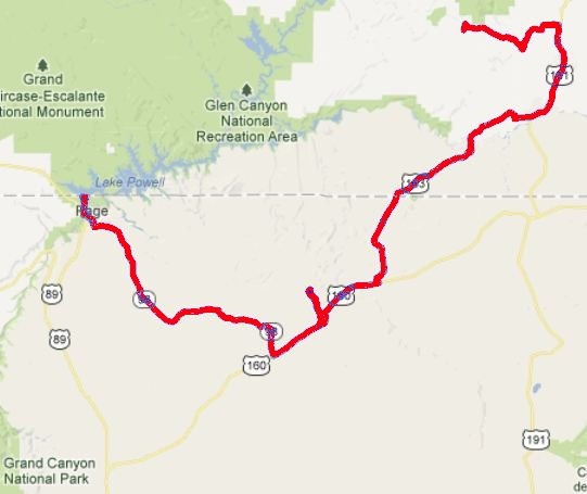
Our route from Natural Bridges National Monument to Wahweap campground at Lake Powell on the Utah – Arizona border included a lunch stop and short hike at Navajo National Monument.  We stayed at Wahweap two nights before heading to the north rim of the Grand Canyon.

2011 drive from Navajo National Monument to Wahweap campground near Page, Arizona.
0 comments
None

Light.

Old Faithful Inn, Yellowstone National Park, Wyoming, September 14, 2007_thumb[2]

Old Faithful Inn, Yellowstone National Park, Wyoming, September 14, 2007

This photo was used in the following video.  (View on YouTube.)

0 comments
None

Raven.

Raven, Yellowstone National Park, Wyoming, September 12, 2007

Raven, Yellowstone National Park, Wyoming, September 12, 2007

View video on YouTube.

0 comments
None

Changed interpretations?

This commentary is not about the science of climate change, though it is about change of a sort – change in how historical temperature information is being presented.

1999

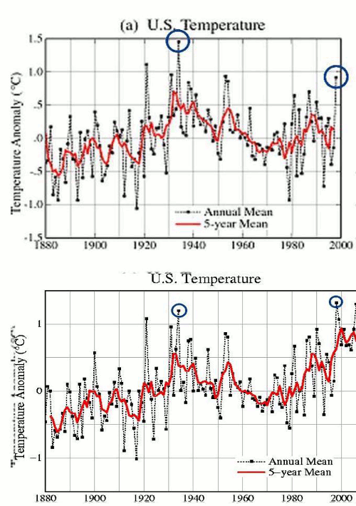
An August 1999 Science Brief  from Goddard Institute for Space Studies stated, “The U.S. has warmed during the past century, but the warming hardly exceeds year-to-year variability. Indeed, in the U.S. the warmest decade was the 1930s and the warmest year was 1934.”1

The figure on the right, a trace of U.S. mean surface temperature anomaly2 for the contiguous 48 United States from 1880 to 1999 was included in the brief.  It clearly shows 1934 almost half a degree Celsius warmer than any other temperature in the figure and 0.6°C  (1.1°F) warmer than 1998.

2012Over the last 12.5 years, adjustments have been made such that the current version of the NASA GISS figure is different than that provided in the 1999 science brief.  When queried about the adjustments, NASA officials claim that the adjustments are small and not significant.  However, 1998 is now shown as higher than 1934 with a 0.7°C change relative to each other.  That’s equivalent to 23% of the total anomaly scale being used.

Below the two figures is a “blink comparator” images that shows, in animated form, how the information has been altered.  To me, it appears that the values have been changed from showing an overall average lowering of temperature in the 48 contiguous states since about 1934 to an overall rise in temperature since 1880.

1998changesannotatedNASA’s Goddard Institute for Space Studies (GISS) climate dataset is one of the world’s major climate sources of information for current and past climate information.  Policies and decision making related to climate are based on it.

Almost 30% of the world’s historic climate stations are in the United States – and almost 50% since 1990 –, yet the U.S. comprises only 2% of the earth’s surface.

_______

1 Whither U.S. Climate? by James Hansen, Reto Ruedy, Jay Glascoe and Makiko Sato — August 1999 (Note: This document no longer appears to be available on the NASA GISS website, but can be found on Internet Archive.  The GISS website is currently down and from what I can tell from reading other online sources, it’s been down for at least a couple of days.)
2 Temperature anomaly – a departure from a reference value or long term value.  The 1935 annual temperature was 1.5°C above the average long-term temperature.

Sunday Commentary for January 13, 2013.

0 comments
None

Lewistown.

Lewistown, Montana, September, 2007

Lewistown, Montana, September, 2007

Video link on YouTube

While in Montana in September 2007, we had plans to stop in Lewistown to get set up with a satellite internet system.  The installer, Ron, had an extra RV spot at his home for friends, complete with hookups and invited us to stay there for a few days.  The satellite system was a new model and there were a few wrinkles in getting it set up right.

0 comments
None

New Video–Navajo National Monument.

On October 1, 2011, we left our campsite in the “overflow” camping area near Natural Bridges National Monument in Utah.  We had camping reservations at the Grand Canyon’s north rim, but, on the way, had two nights reserved at the Wahweap campground near Page, Arizona.

Around lunch time, we took a side trip to Navajo National Monument and, after eating, took a hike to a viewpoint overlooking Betatakin cliff dwellings.

Betatakin dwellings - Navajo National Monument

From Wikipedia:

Navajo National Monument is located within the northwest portion of the Navajo Reservation in northern Arizona.

Navajo National Monument preserves three of the most intact cliff dwellings of the ancestral puebloan people (Hisatsinom). The Navajo people who live here today call these ancient ones Anasazi. The monument is high on the Shonto plateau, overlooking the Tsegi Canyon system in the Navajo Nation in northern Arizona. The monument, located west of Kayenta, Arizona, features a visitor center with a museum, two short self-guided mesa top trails, two small campgrounds, and a picnic area. Rangers guide visitors on free tours of the Keet Seel (Kitsʼiil) and Betatakin (Bitátʼahkin) cliff dwellings. The Inscription House site (Tsʼah Biiʼ Kin), further west, is currently closed to public access.

The Sandal Trail is an accessible self-guided walk that provides views of the spectacular canyonlands and rugged topography near the visitor center. Interpretive signs provide information on local flora and other topics. The 1.6 km round-trip trail ends at an overlook of the Betatakin ruins across the 560 feet (170 m) deep Betatakin Canyon.

Link to video on YouTube.

Selected Information Resources: Navajo National Monument

0 comments
None